In 1857-58, while John Butterfield and his associates were laying out a cross-country stagecoach route and setting up relay stations to support the Overland Mail’s 24-day traverse from the Mississippi River to the Pacific Coast, another transportation pioneer was surveying for a national wagon road. Lieutenant Edward F. Beale’s route went directly west along the 35th Parallel, from Fort Smith, Arkansas, to the Colorado River. In this massive undertaking, he determined that many of the abundant streams in eastern Indian Territory required bridging, and six of them would be spanned with iron bridges.
For a comprehensive account of Beale’s efforts and the story of the iron bridges, see Dr. Carroll J. Messer’s paper on the subject:
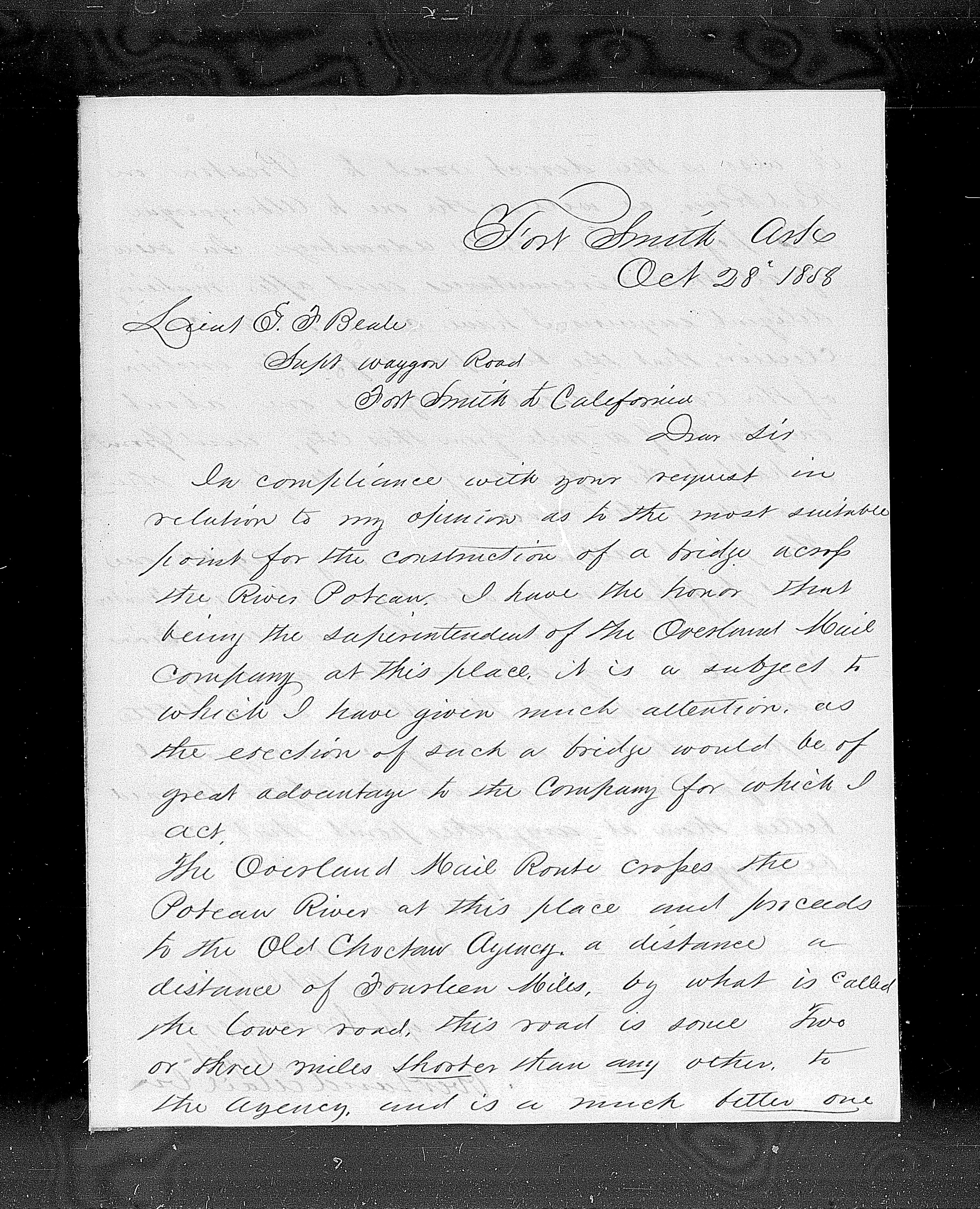
The iron bridges completed first crossed (east to west) Redbank Creek, Otter Creek, Sans Bois Creek, Emachaya Creek, and Little River. The easternmost, last to be built and largest, a two-span bridge versus one span over the other streams, would cross the Poteau River, near Fort Smith. The specific location for this bridge created some controversy, however. Since Butterfield’s Overland Mail Company was an active user of the road from Fort Smith into Indian Territory and would benefit from such a bridge, Beale asked Hugh Crocker, superintendent for the Overland Mail in that division, for his opinion on the bridge’s location. In a letter dated October 28, 1858, Crocker affirmed that “the erection of such a bridge would be of great advantage to the Company for which I act.”
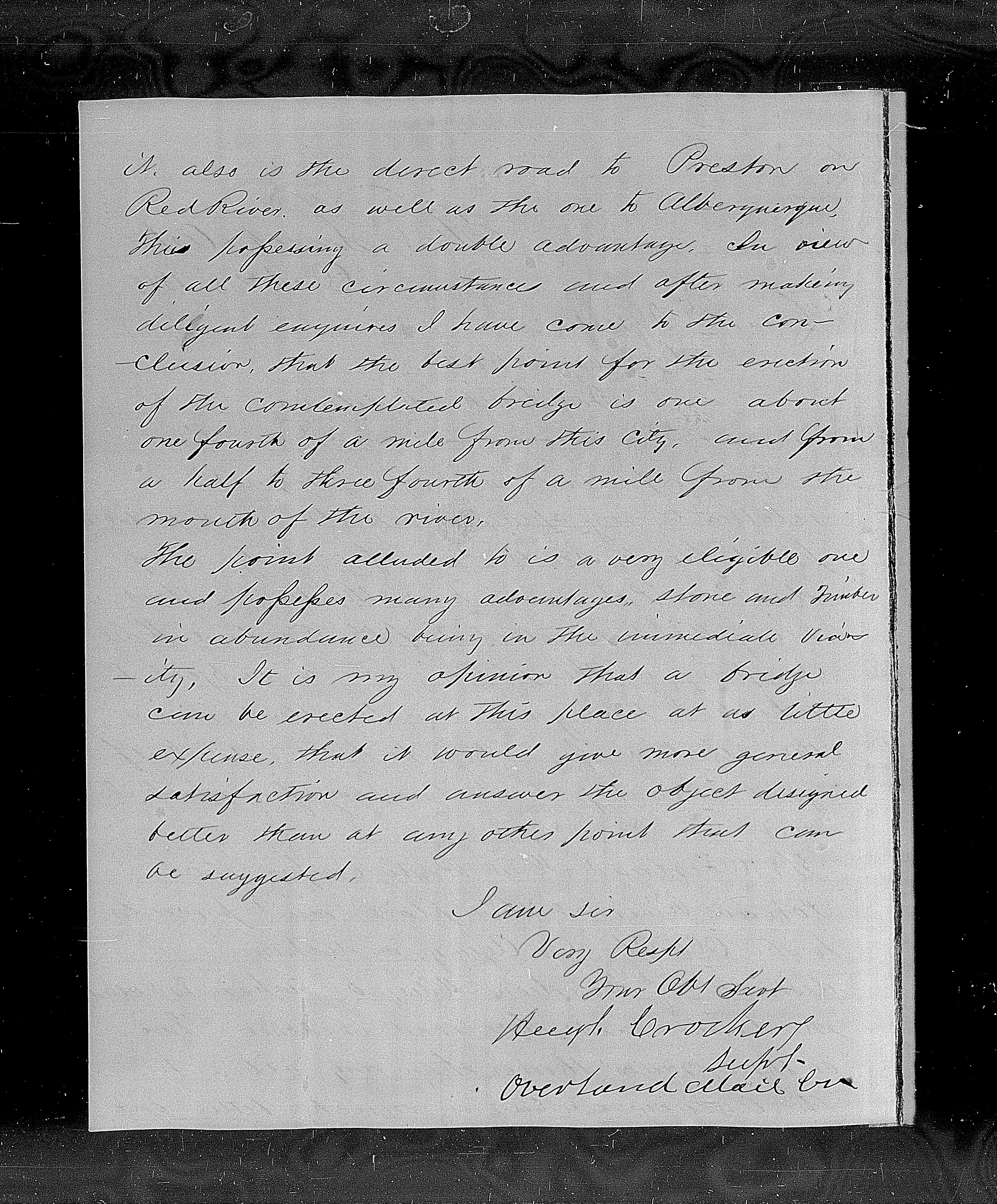
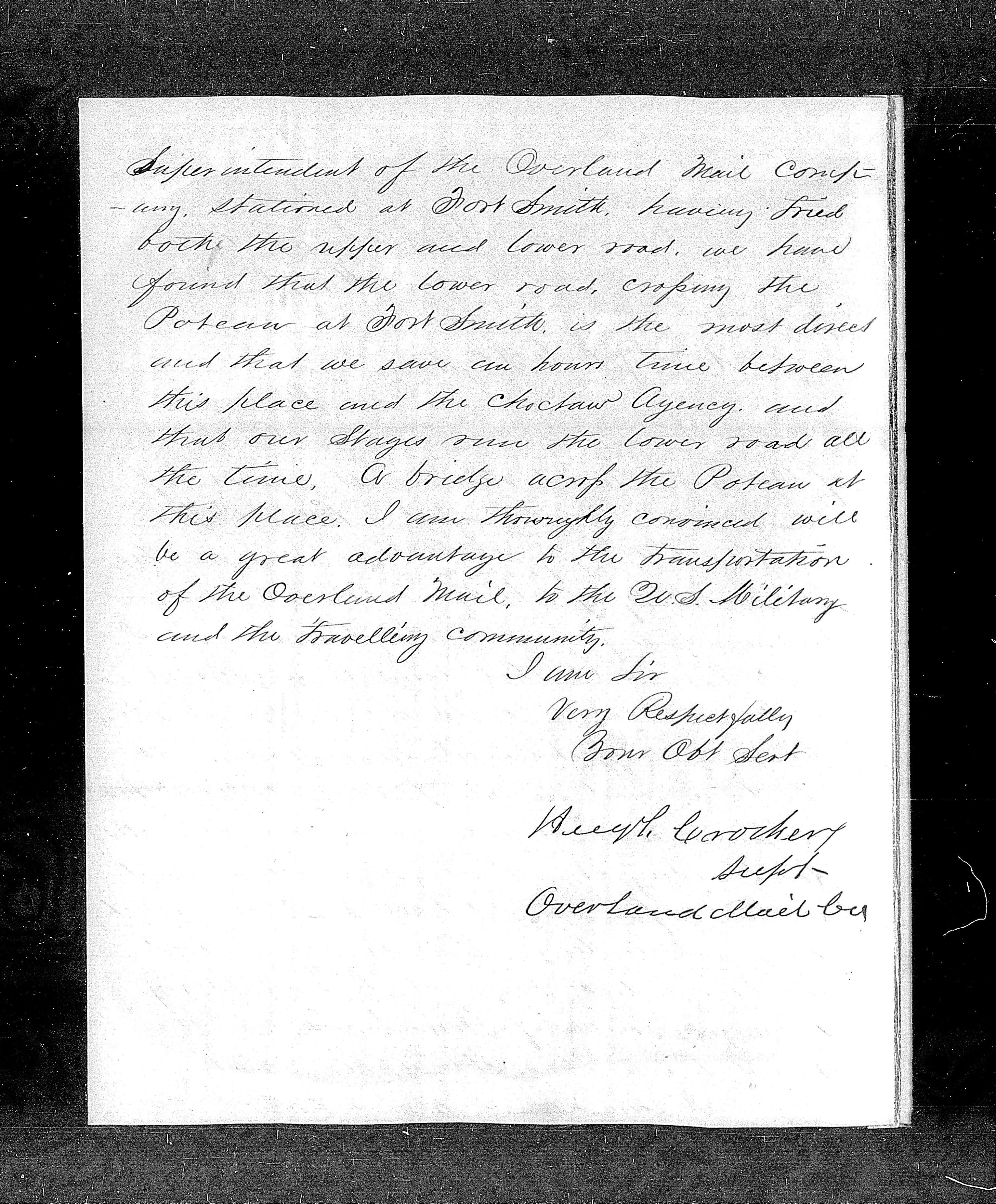
Crocker continued: “The Overland Mail Route crosses the Poteau River at this place (Fort Smith) and proceeds to the old Choctaw Agency, a distance of fourteen miles by what is called the lower road, this road is some two or three miles shorter than any other to the Agency and is a much better one. It is also the direct road to Preston on Red River as well as the one to Albuquerque, thus possessing a double advantage.” Crocker then went on to recommend the best point for the bridge to be about one-fourth of a mile from Fort Smith and from half to three-fourths of a mile from the river’s mouth. This location’s advantages were many, he stated, including abundant stone and timber.
By spring of 1859, construction on the Poteau River bridge was about to begin but its planned location created a furor in Fort Smith. McLean’s Ferry, 10 miles south of Fort Smith, had been designated as the bridge site, rather than a location close to the town and fort. In protest, Fort Smith citizens and prominent businessmen directed a letter writing campaign to John B. Floyd, Secretary of War, under whose orders Beale was operating. The campaign included individual letters from notables such as Judge John Wheeler, who rode with Waterman Ormsby on the first westbound Butterfield stage, and John Rogers, founder of the town of Fort Smith, as well as a petition signed by a large contingent of Fort Smith citizens.
The McLean’s Ferry route, they complained, would be four or five miles longer than the existing road, and would pass through a river bottom impassable much of the year.
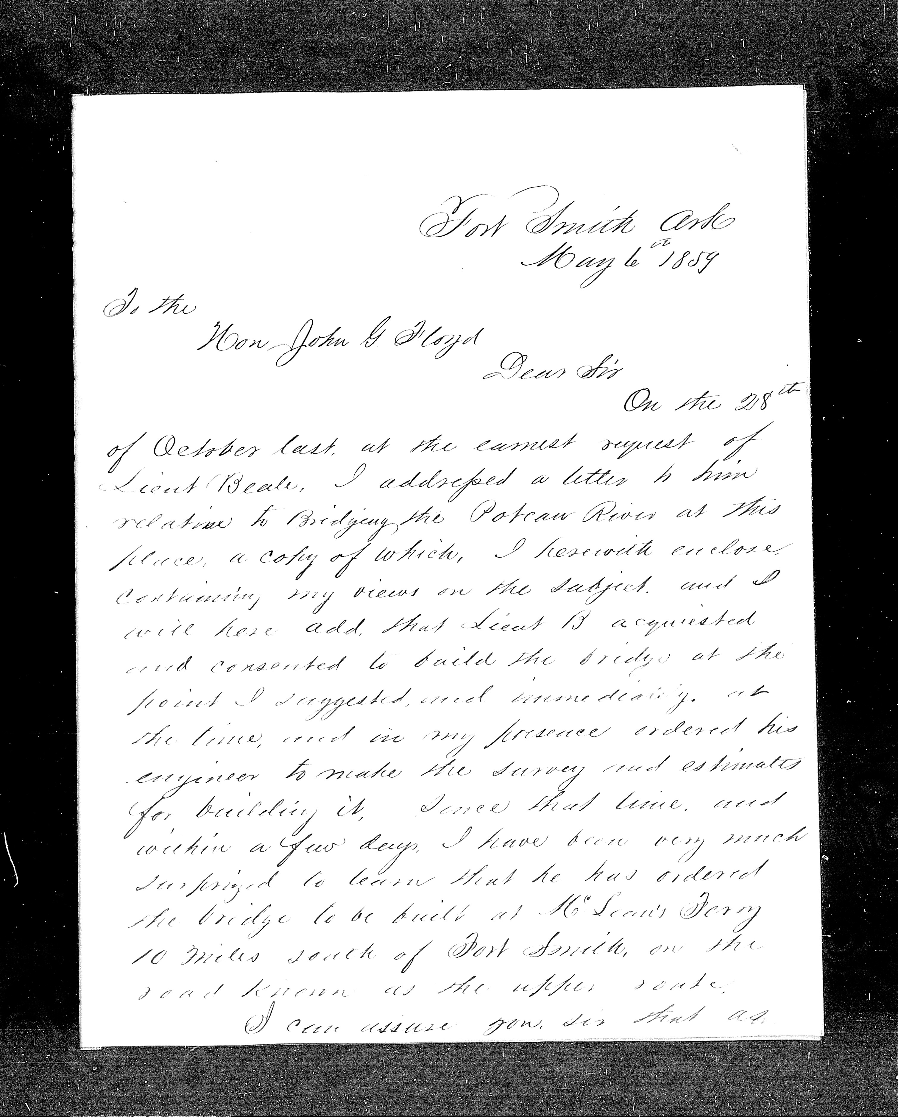
On May 6, 1859, the Overland Mail Company’s Hugh Crocker entered into the conversation again in a letter to Floyd. Crocker stated that in his presence Beale had agreed to put the bridge where the Overland Mail Company superintendent recommended, and had at the same time ordered his engineers to make the survey and estimates to build it. Crocker expressed surprise at the plans to build the bridge at McLean’s Ferry on the road known as the Upper Route.
The Overland Mail stages ran the Lower Road (traversing the finger of land between the Poteau and the Arkansas rivers) all the time, wrote Crocker, saving an hour’s time and being most direct between Fort Smith and the Choctaw Agency. “A bridge across the Poteau at this place (Fort Smith) will be a great advantage to the transportation of the Overland Mail, to the U.S. Military and the travelling community,” wrote Crocker.
On May 18, 1859, the Acting Secretary of War suspended operations to build the bridge at McLean’s Ferry. On July 12, 1859, he ordered that a more satisfactory place for the crossing be determined. He stated that this was all a “misapprehension.” It was never Beale’s intention to build the bridge at McLean’s Ferry, he wrote, but when Beale’s large survey team of building and supply wagons attempted to cross at Allen’s Ferry they faced an obstruction, forcing them to cross at McLean’s instead. It was then mistakenly assumed this ferry site would be the bridge site, leading to all the consternation.
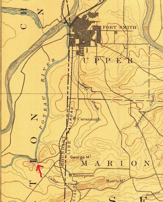
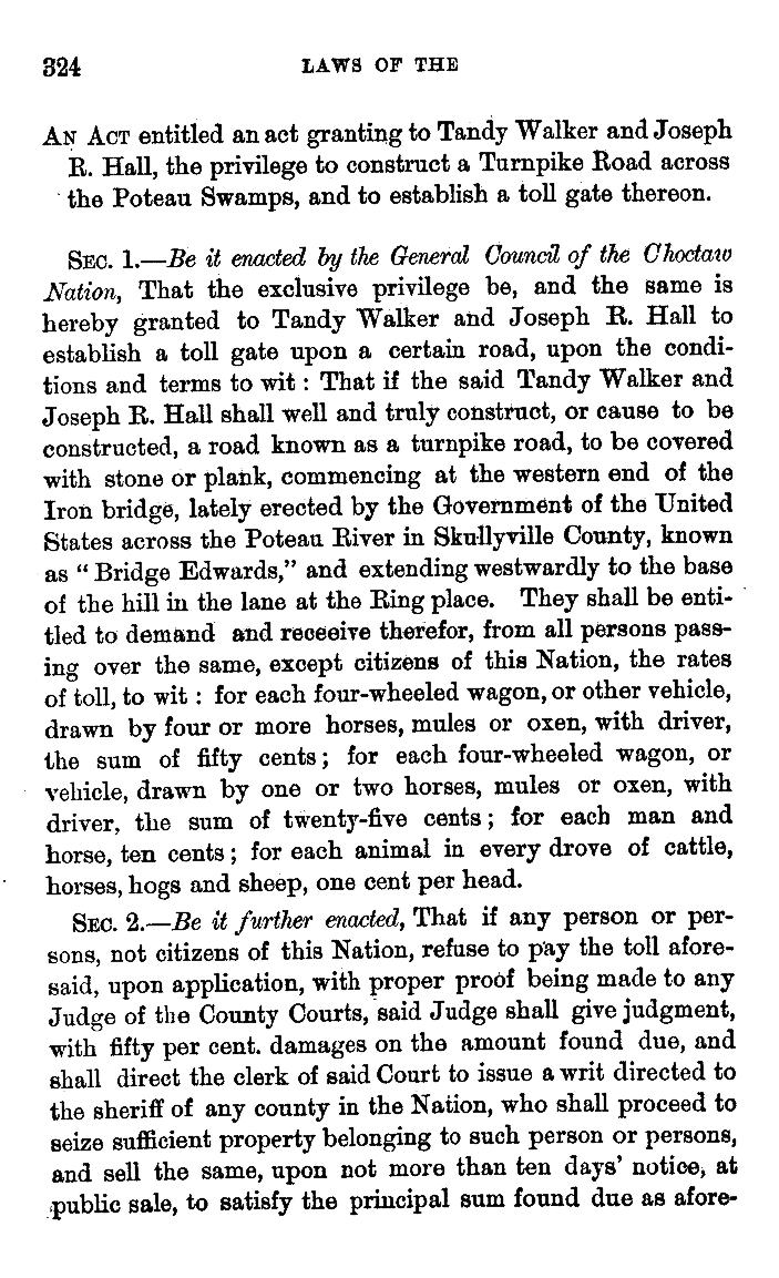
Ultimately, the bridge was built at the site of Allen’s Ferry. By 1860, the bridge was in place and, by that summer, the new road crossing the Poteau River to Fort Smith was very busy. Evidently the populace had accepted the location. A better road across the river bottom (Braden Bottom or “the Poteau Swamps”) to the Choctaw Agency was needed, however, commencing at the western end of the Iron Bridge and extending to the Ring place, a location on the Overland Mail Road east of Skullyville. Thus, Choctaw Governor Tandy Walker, who ran the Butterfield station at the Choctaw Agency, requested a concession from the Choctaw General Council to build a toll road. This concession was granted October 31, 1860.
. composeds by Folsom, Joseph P [New York city, W.P. Lyon & son, 1869] Pdf. https://www.loc.gov/item/22025915/.
Do we know whether the stagecoaches of the Overland Mail Company actually used the iron bridge over the Poteau? There is no direct evidence coming from passenger journals or other firsthand reports. The Overland Mail Company’s active engagement in the decision making about the bridge’s location suggests, however, that they planned to use the bridged route if it were sited to their satisfaction. The apparent willingness of the Secretary of War to appease the interests of the citizens and business interests of Fort Smith suggests their intention would also have included satisfying the Overland Mail Company. It seems probable that the Butterfield stagecoaches took advantage of the new bridge.
With the onset of the Civil War, the last Overland Mail stagecoach passed through Fort Smith in March of 1861. We don’t know what route it took across the Poteau. We do know that about a month later the federal troops at Fort Smith evacuated just ahead of Confederate forces, escaping to Indian Territory by way of the bridged road and destroying the bridges behind them. When Lieutenant William Woods Averell followed in their path a few days later to deliver orders to evacuate for Col. William H. Emory, commander of federal forces in Indian Territory, he traveled south out of Fort Smith, coming to the now-destroyed bridge, and swam with his horse across the Poteau.
For more on Lieut. Averell’s harrowing ride, see: https://gateway.okhistory.org/ark:/67531/metadc2123780/
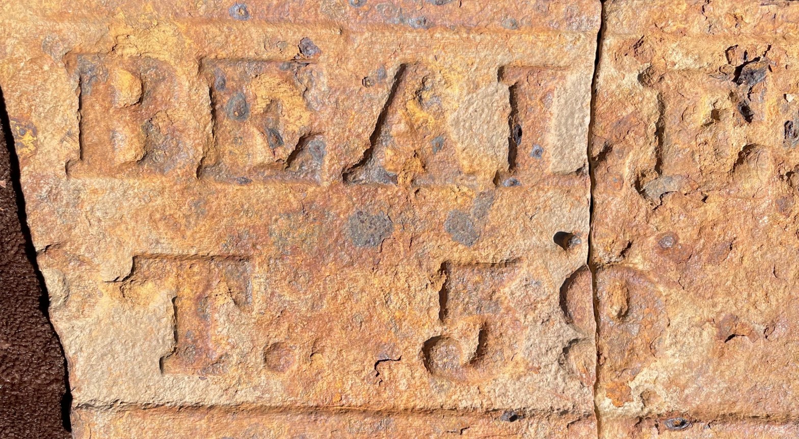
Read about an important artifact found in 2020 at one of the iron bridge sites in LeFlore County, Oklahoma. Here’s my article in the Chronicles of Oklahoma on that subject:

Thank you, Susan. A fascinating story indeed.