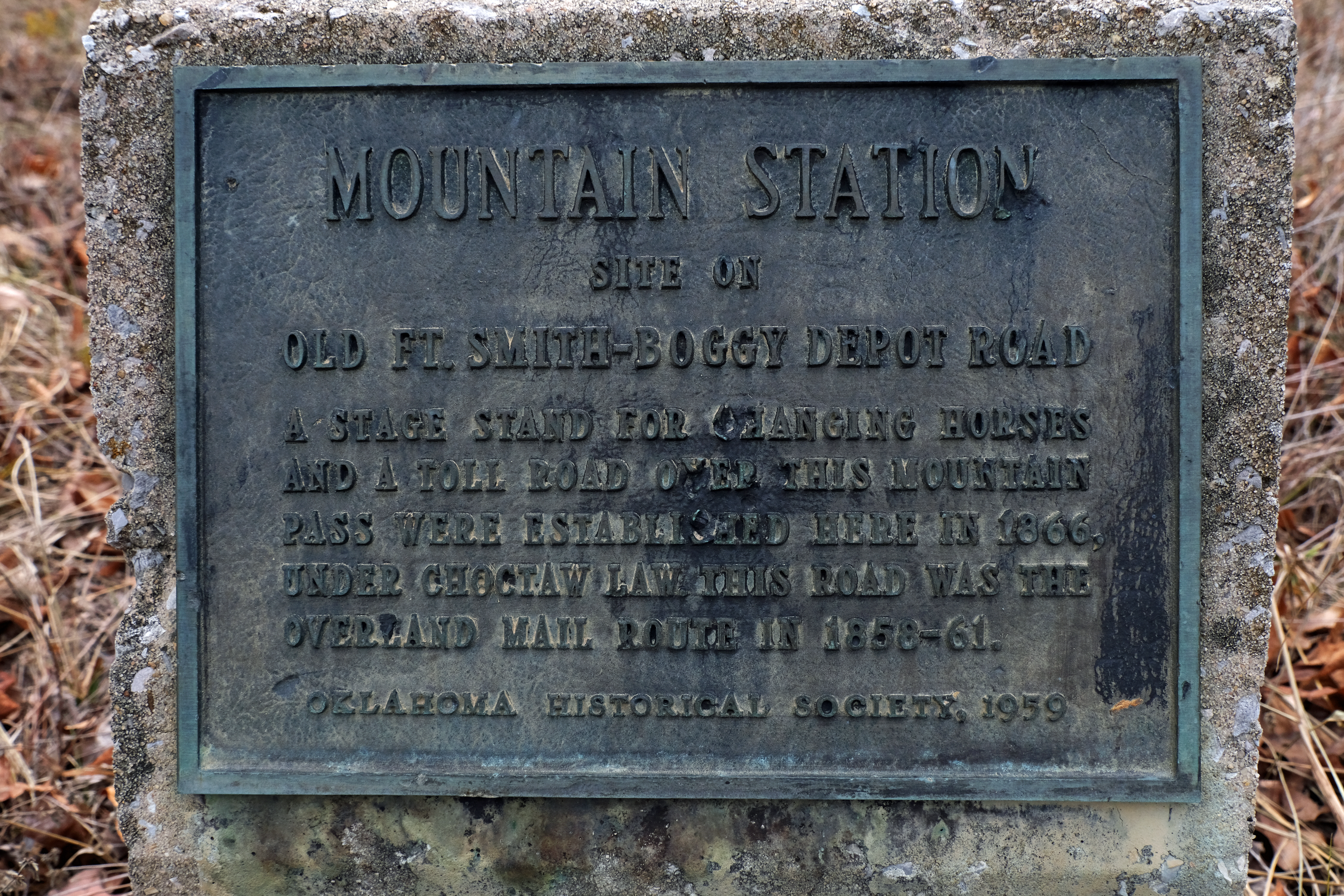
In 1857-58, while John Butterfield and his associates were laying out a cross-country stagecoach route and setting up relay stations to support the Overland Mail’s 24-day traverse from the Mississippi River to the Pacific Coast, another transportation pioneer was surveying for a national wagon road. Lieutenant Edward F. Beale’s route went directly west along the 35th Parallel, from Fort Smith, Arkansas, to the Colorado River. In this massive undertaking, he determined that many of the abundant streams in eastern Indian Territory required bridging, and six of them would be spanned with iron bridges.
For a comprehensive account of Beale’s efforts and the story of the iron bridges, see Dr. Carroll J. Messer’s paper on the subject:
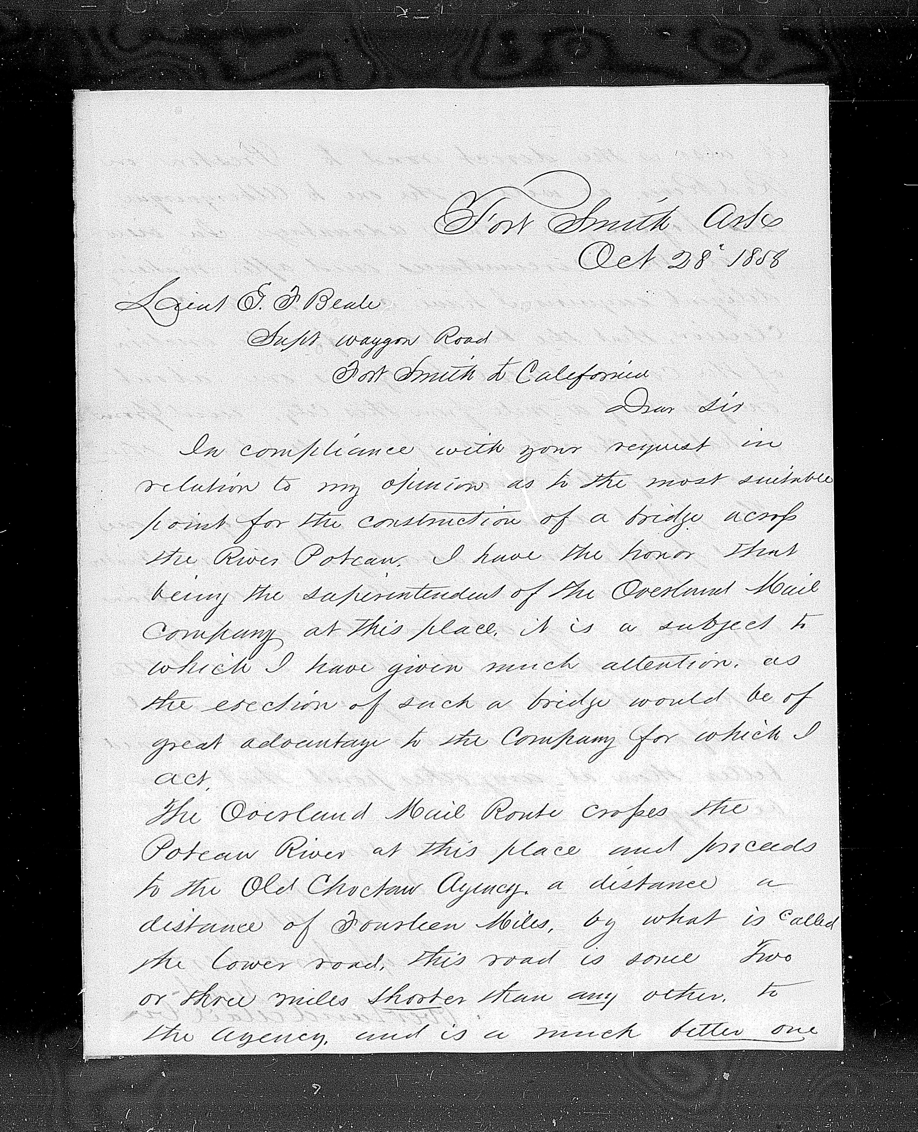
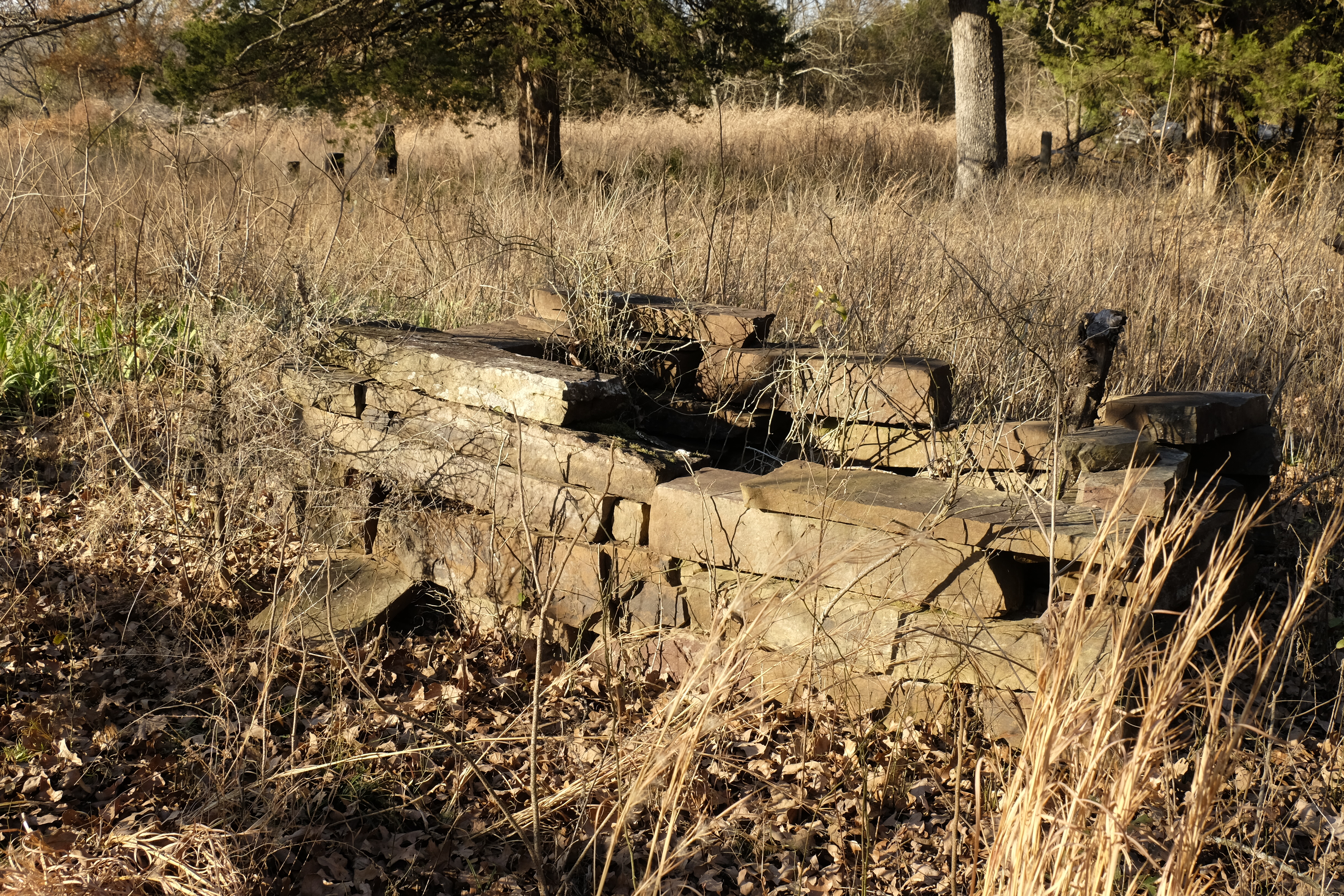
The iron bridges completed first crossed (east to west) Redbank Creek, Otter Creek, Sans Bois Creek, Emachaya Creek, and Little River. The easternmost, last to be built and largest, a two-span bridge versus one span over the other streams, would cross the Poteau River, near Fort Smith. The specific location for this bridge created some controversy, however. Since Butterfield’s Overland Mail Company was an active user of the road from Fort Smith into Indian Territory and would benefit from such a bridge, Beale asked Hugh Crocker, superintendent for the Overland Mail in that division, for his opinion on the bridge’s location. In a letter dated October 28, 1858, Crocker affirmed that “the erection of such a bridge would be of great advantage to the Company for which I act.”
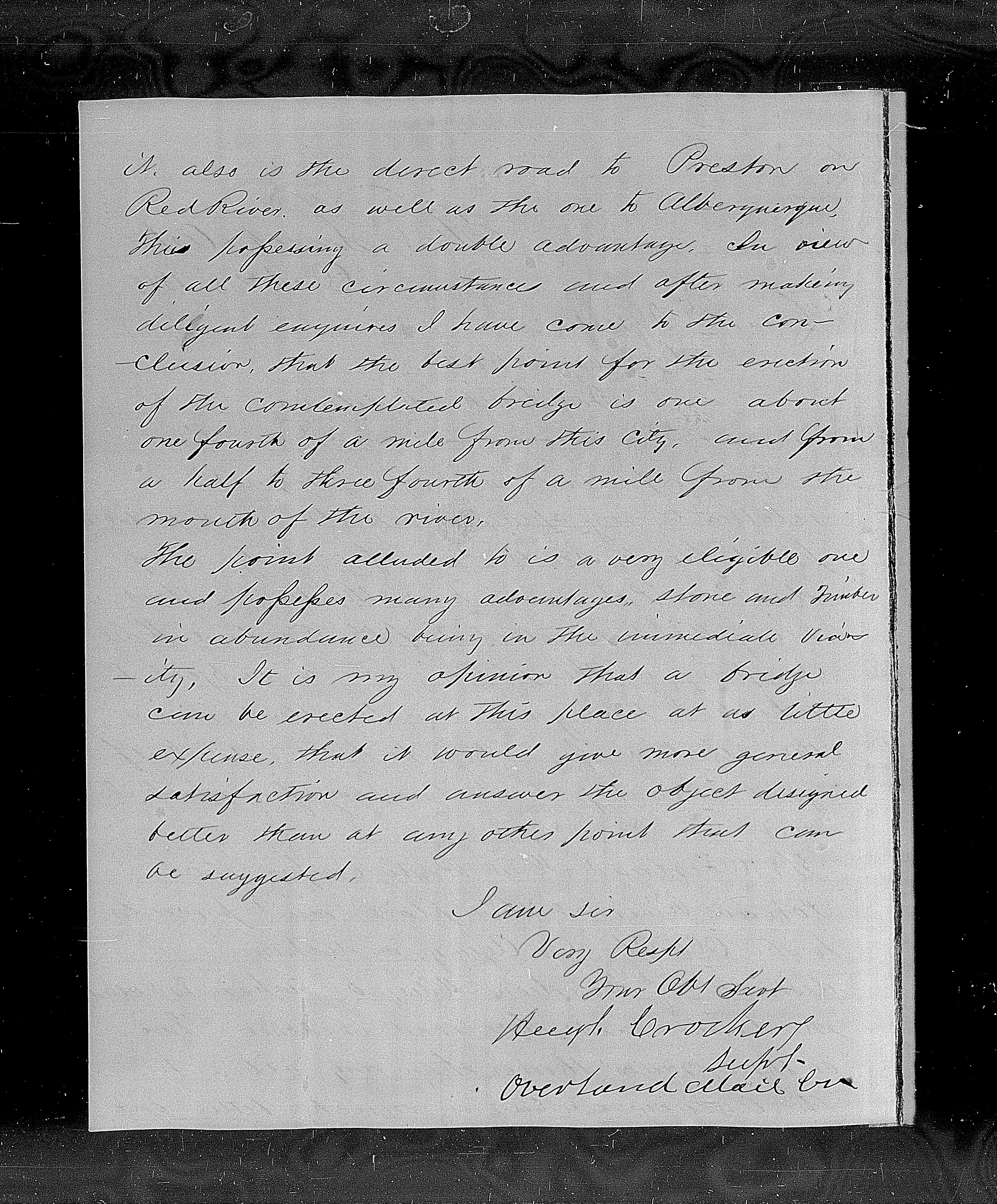
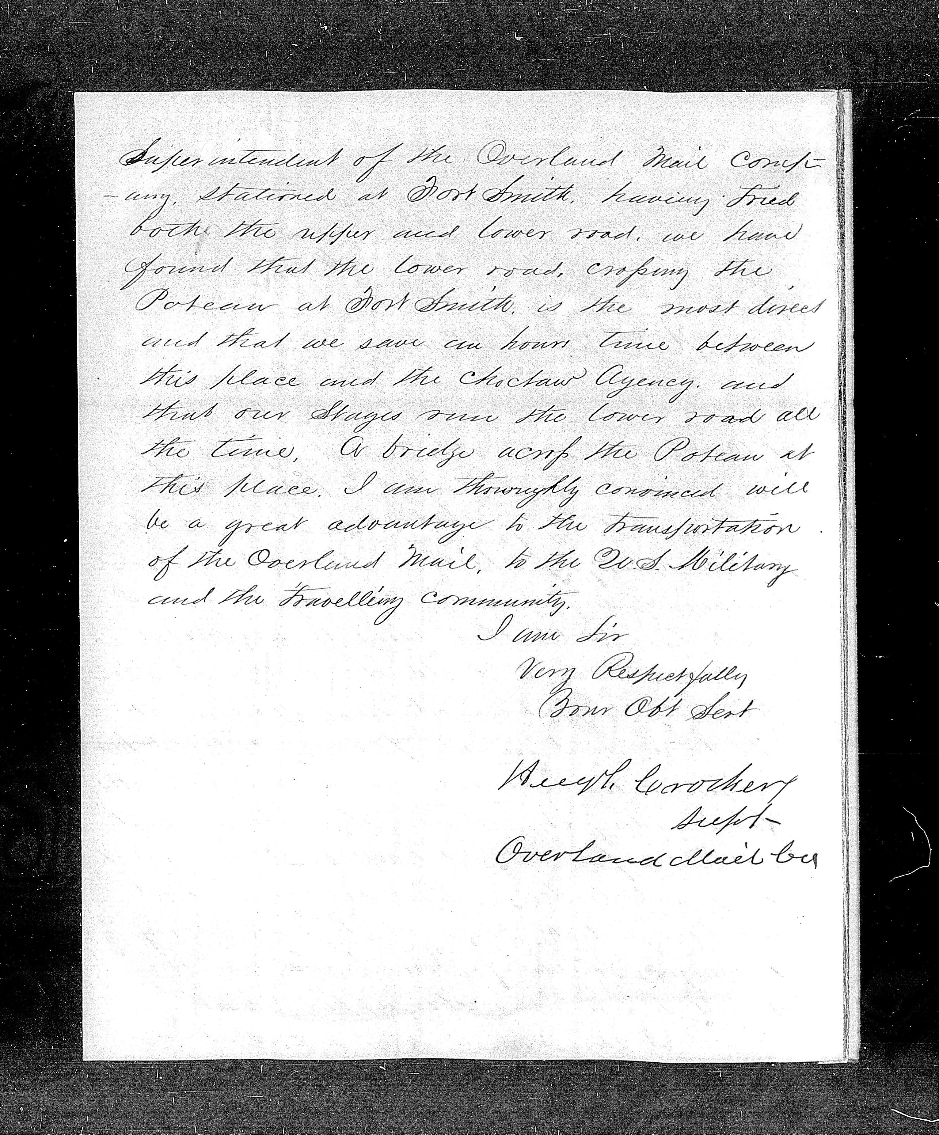
Crocker continued: “The Overland Mail Route crosses the Poteau River at this place (Fort Smith) and proceeds to the old Choctaw Agency, a distance of fourteen miles by what is called the lower road, this road is some two or three miles shorter than any other to the Agency and is a much better one. It is also the direct road to Preston on Red River as well as the one to Albuquerque, thus possessing a double advantage.” Crocker then went on to recommend the best point for the bridge to be about one-fourth of a mile from Fort Smith and from half to three-fourths of a mile from the river’s mouth. This location’s advantages were many, he stated, including abundant stone and timber.
Hugh Crocker letter to Beale, October 28, 1858, page one.
Hugh Crocker letter to Beale, October 28, 1858, page two.
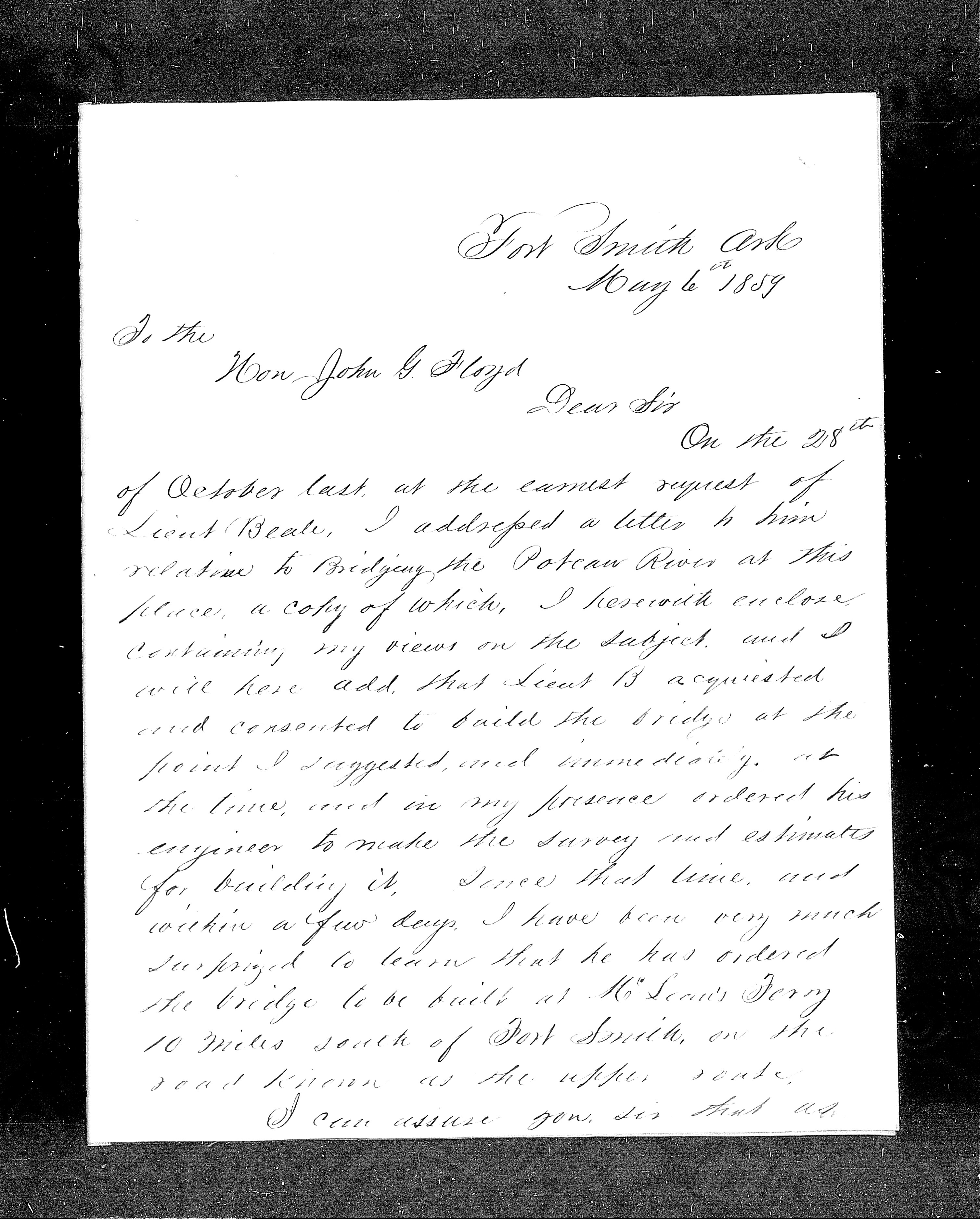
By spring of 1859, construction on the Poteau River bridge was about to begin but its planned location created a furor in Fort Smith. McLean’s Ferry, 10 miles south of Fort Smith, had been designated as the bridge site, rather than a location close to the town and fort. In protest, Fort Smith citizens and prominent businessmen directed a letter writing campaign to John B. Floyd, Secretary of War, under whose orders Beale was operating. The campaign included individual letters from notables such as Judge John Wheeler, who rode with Waterman Ormsby on the first westbound Butterfield stage, and John Rogers, founder of the town of Fort Smith, as well as a petition signed by a large contingent of Fort Smith citizens.
The McLean’s Ferry route, they complained, would be four or five miles longer than the existing road, and would pass through a river bottom impassable much of the year.
On May 6, 1859, the Overland Mail Company’s Hugh Crocker entered into the conversation again in a letter to Floyd. Crocker stated that in his presence Beale had agreed to put the bridge where the Overland Mail Company superintendent recommended, and had at the same time ordered his engineers to make the survey and estimates to build it. Crocker expressed surprise at the plans to build the bridge at McLean’s Ferry on the road known as the Upper Route.
The Overland Mail stages ran the Lower Road (traversing the finger of land between the Poteau and the Arkansas rivers) all the time, wrote Crocker, saving an hour’s time and being most direct between Fort Smith and the Choctaw Agency. “A bridge across the Poteau at this place (Fort Smith) will be a great advantage to the transportation of the Overland Mail, to the U.S. Military and the travelling community,” wrote Crocker.
On May 18, 1859, the Acting Secretary of War suspended operations to build the bridge at McLean’s Ferry. On July 12, 1859, he ordered that a more satisfactory place for the crossing be determined. He stated that this was all a “misapprehension.” It was never Beale’s intention to build the bridge at McLean’s Ferry, he wrote, but when Beale’s large survey team of building and supply wagons attempted to cross at Allen’s Ferry they faced an obstruction, forcing them to cross at McLean’s instead. It was then mistakenly assumed this ferry site would be the bridge site, leading to all the consternation.
Hugh Crocker letter to Floyd, May 6, 1859, page one.
Hugh Crocker letter to Floyd, May 6, 1859, page two.
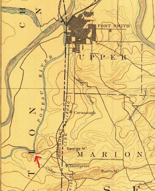
1890 Map, arrow showing site of iron bridge crossing on the Poteau.
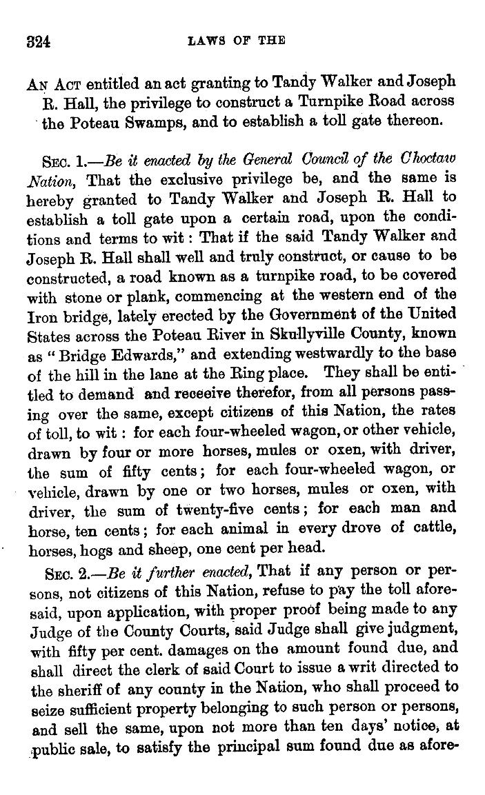
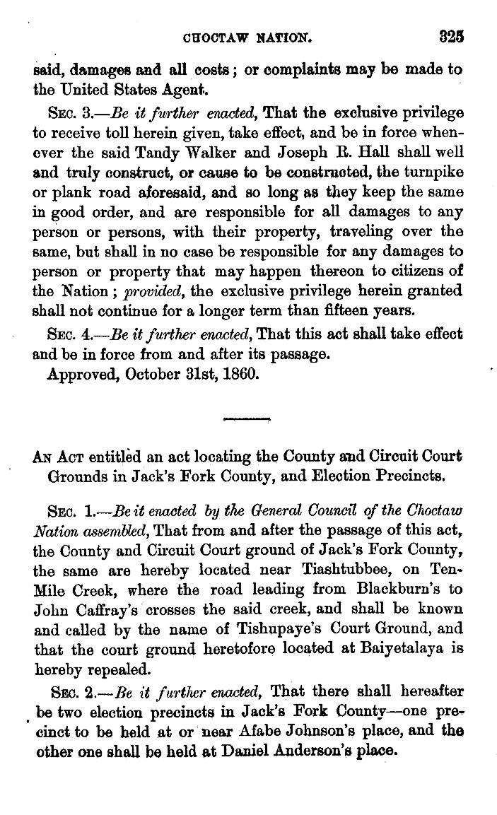
Ultimately, the bridge was built at the site of Allen’s Ferry. By 1860, the bridge was in place and, by that summer, the new road crossing the Poteau River to Fort Smith was very busy. Evidently the populace had accepted the location. A better road across the river bottom (Braden Bottom or “the Poteau Swamps”) to the Choctaw Agency was needed, however, commencing at the western end of the Iron Bridge and extending to the Ring place, a location on the Overland Mail Road east of Skullyville. Thus, Choctaw Governor Tandy Walker, who ran the Butterfield station at the Choctaw Agency, requested a concession from the Choctaw General Council to build a toll road. This concession was granted October 31, 1860.
Choctaw Nation. Constitution and laws of the Choctaw nation. Together with the treaties of , 1865 and 1866 . composeds by Folsom, Joseph P [New York city, W.P. Lyon & son, 1869] Pdf. https://www.loc.gov/item/22025915/.
Do we know whether the stagecoaches of the Overland Mail Company actually used the iron bridge over the Poteau? There is no direct evidence coming from passenger journals or other firsthand reports. The Overland Mail Company’s active engagement in the decision making about the bridge’s location suggests, however, that they planned to use the bridged route if it were sited to their satisfaction. The apparent willingness of the Secretary of War to appease the interests of the citizens and business interests of Fort Smith suggests their intention would also have included satisfying the Overland Mail Company. It seems probable that the Butterfield stagecoaches took advantage of the new bridge.
With the onset of the Civil War, the last Overland Mail stagecoach passed through Fort Smith in March of 1861. We don’t know what route it took across the Poteau. We do know that about a month later the federal troops at Fort Smith evacuated just ahead of Confederate forces, escaping to Indian Territory by way of the bridged road and destroying the bridges behind them. When Lieutenant William Woods Averell followed in their path a few days later to deliver orders to evacuate for Col. William H. Emory, commander of federal forces in Indian Territory, he traveled south out of Fort Smith, coming to the now-destroyed bridge, and swam with his horse across the Poteau.
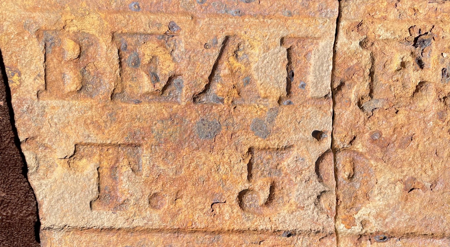
Read about an important artifact found in 2020 at one of the iron bridge sites in LeFlore County, Oklahoma. Here’s my article in the Chronicles of Oklahoma on that subject:
In 1852, Captain Randolph Barnes Marcy was the first American to locate the headwaters of the Red River . . . or was he? Read about our adventures retracing his steps in the Spring 2026 issue of Overland Journal.
Gravel flies as a Jeep skids to a halt in front of us. “What are you doing here?” the driver shouts as he jumps out. Joseph Wolf and I are both startled, and I am definitely puzzled. I had secured permission from the property owner to visit the site of old Brazil Station, or so I thought.
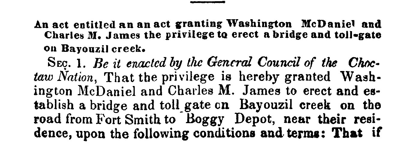
Located along the Butterfield Overland Mail Road about fourteen miles southwest of Skullyville in the Choctaw Nation, Brazil Station was founded as a trading post after the Civil War by David Robert Welch, an Irishman who came to Indian Territory via Alabama. Although the site was not an official Butterfield stand, the Choctaw legislature awarded Washington McDaniel and Charles M. James the concession for a toll bridge across nearby Brazil Creek in October 1858, concurrent with the initiation of the Overland Mail.
The location also served as a local mail stop.[i] Butterfield historians Roscoe and Margaret Conkling and Muriel Wright spent considerable time here on their retracing adventures. Following suit, Joe and I have been examining the ruins, a cemetery and a road trace. Oblivious to the idea that we could be trespassing, we showed up on a game camera and the property owner alerted a friend, who is the man accosting us now. I explain that we have the owner’s permission to be here, making sure he knows that Joe is with the Choctaw Nation’s Office of Historic Preservation in hopes that it will lend us some credibility . . . and safety.
Joe Wolf at Brazil Station before we were accosted.
“Who’s the property owner?” he demands, maintaining his sternness but becoming somewhat less threatening. I tell him her name and he informs me she sold the property to his friend some time ago. At first I am shocked and then feel utterly betrayed. I was in contact with her that very morning, even at the moment Joe and I parked at the gate. I knew she was eccentric, but never dreamed she would intentionally deceive and endanger us. At our first meeting, she arrived in a pickup studded with auxiliary lights for catching poachers, making threats about what she would do to trespassers and stating not so subtly how suitable old wells are for hiding bodies. From that moment on I knew not to cross her and scrupulously obtained her permission for each subsequent visit, but now I see that my ginger handling of the relationship was for naught. Thankfully, the Jeep driver softens up and gives me the name and phone number of the current owner for future use. And, on the bright side, I have now made four visits to Brazil Station without getting shot. Certainly, other early travelers along the old stagecoach road did not feel entirely safe during their traverse of Indian Territory so I suppose it could be considered a meaningful moment of empathy.
As I have explored the remnants of the Butterfield Overland Mail stagecoach road in Oklahoma, my experience with property owners has been consistently positive other than this, and even this one seemed friendly at first. Trespassing is taken seriously here, and with few exceptions, I have been scrupulous about contacting the owner and asking permission before visiting a site on private property.
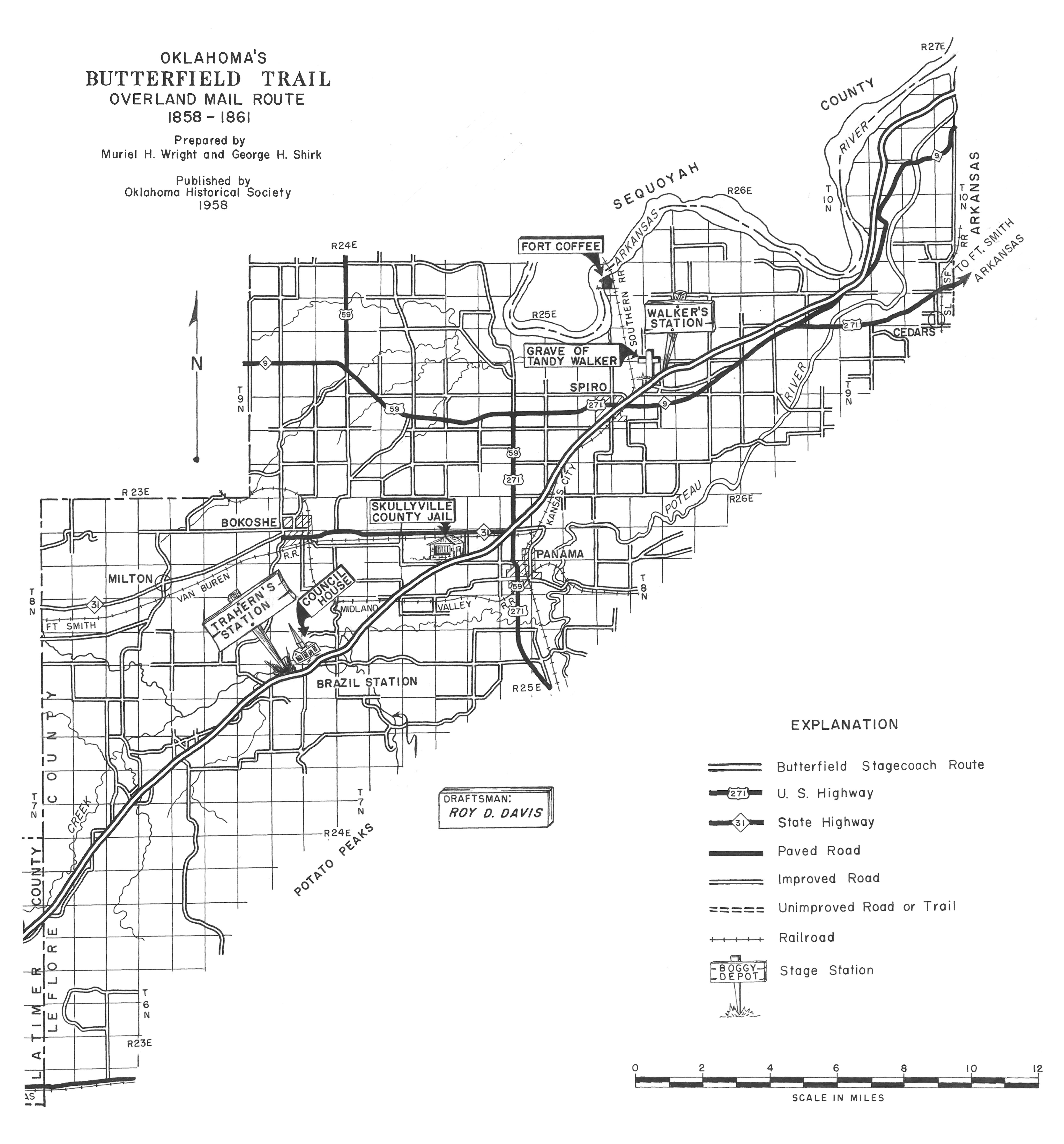
Butterfield Stagecoach Route map for LeFlore County, Oklahoma, from 1958 Centennial Committee report.
The Path of the Old Road
After leaving Walker’s Station, the easternmost Butterfield station in Indian Territory fifteen miles from Fort Smith, the Butterfield Overland Mail stagecoach road passed the present town of Spiro to the south, running southwest toward the Coal Creek crossing. U.S. Highway 271 is close to the line of the old road over part of this distance. About two miles west of Spiro, the road branched into three: the left fork the Overland Mail route, the right fork the road to Edwards Trading Post on Little River in the Creek Nation, and the middle fork Randolph Marcy’s California wagon road.[ii] Near the Coal Creek crossing, the mail road curved sharply west and then southwest again, passing to the south of the Skullyville County Jail, which still sits along Rock Jail Road west of Panama, Oklahoma. On private property but easily viewed from the road, the jail is a one-story sandstone building with walls two feet thick and an iron-barred door and window.
Skullyville County Jail.
Although it did not exist contemporaneously with the Overland Mail’s use of the route, the structure is important as the only surviving building connected with the Skullyville County government of the Choctaw Nation. Originally a courthouse and execution tree also comprised the government complex, built between 1888 and 1895.[iii] The Skullyville County courthouse, which was located north of the jail, burned sometime before 1937.[iv]
From the jail, the mail road continued southwest across Buck Creek, where a mail station was located on a later stage route. It then crossed Brazil Creek, a tributary of the Poteau, and what is known today as Mack Watson Creek. About a quarter of a mile southwest of this last crossing is the site of Brazil Station.
A French Name
But where did the name “Brazil” come from? When I first began to explore the Indian Territory segment of the Butterfield Overland Mail stagecoach line and talked with the locals in LeFlore and Latimer Counties, I noticed “Brazil” was not pronounced the way I expected, i.e. like the country of Brazil in South America, with the emphasis on the second syllable. Instead, in the first syllable the “a” was flattened and drawn out, and the second syllable pronounced like “zeal.” I soon discovered this reflected an alternate spelling, “Brazeale.” Then, I found the creek referred to as “Bayouzil” in historical documents, a discovery which led to its French origins.
Long before the Louisiana Purchase of 1803, French fur trappers and traders of the 1700s hunted and camped along the streams of the Arkansas and Red River valleys in what is now Oklahoma. The names they gave the rivers and mountains reflected the features of the terrain, unusual occurrences, or the routines of daily life, leaving an enduring legacy. Ascending the Arkansas River west of the Oklahoma border, the first stream of any size west is the Poteau, the French word for “post.” The Verdigris River, from the French words “vert” for green and “gris” for gray, evokes the greenish gray color of rocks in the stream. Muriel Wright’s 1929 article in The Chronicles of Oklahoma explores the subject in more detail, mentioning familiar southeastern Oklahoma names like Vian, Sallisaw, Sans Bois and Fourche Maline.[v]
Less obviously French at first was Brazil, but reversing its linguistic corruption made it clear: Brazil, Brazeale, Bayouzil, and on an 1834 map, Bayou Zeal.[vi]
1844 map of Indian Territory
Then, on an 1844 map, I found it labeled “Bayou aux Iles.” “Bayou to the islands.” Perhaps this was its original French name. Why it would be so named remains a mystery.
Back on the Road
Fences through which county roads do not extend now obstruct the path of the old stagecoach road between the jail and Brazil, but a detour over Buck Creek Mountain on Blue Goose Road affords a scenic crossing of Brazil Creek, until recently on a picturesque 1941 Pony Truss bridge, now out of service but still visible off the main road.[vii]
Bill Dragoo driving across Brazil Creek on the old bridge.
It was replaced with a bridge of concrete and greater safety but certainly less charm. South of the bridge, an obscure lane running east accesses the Brazil Cemetery and ruins of Brazil School.
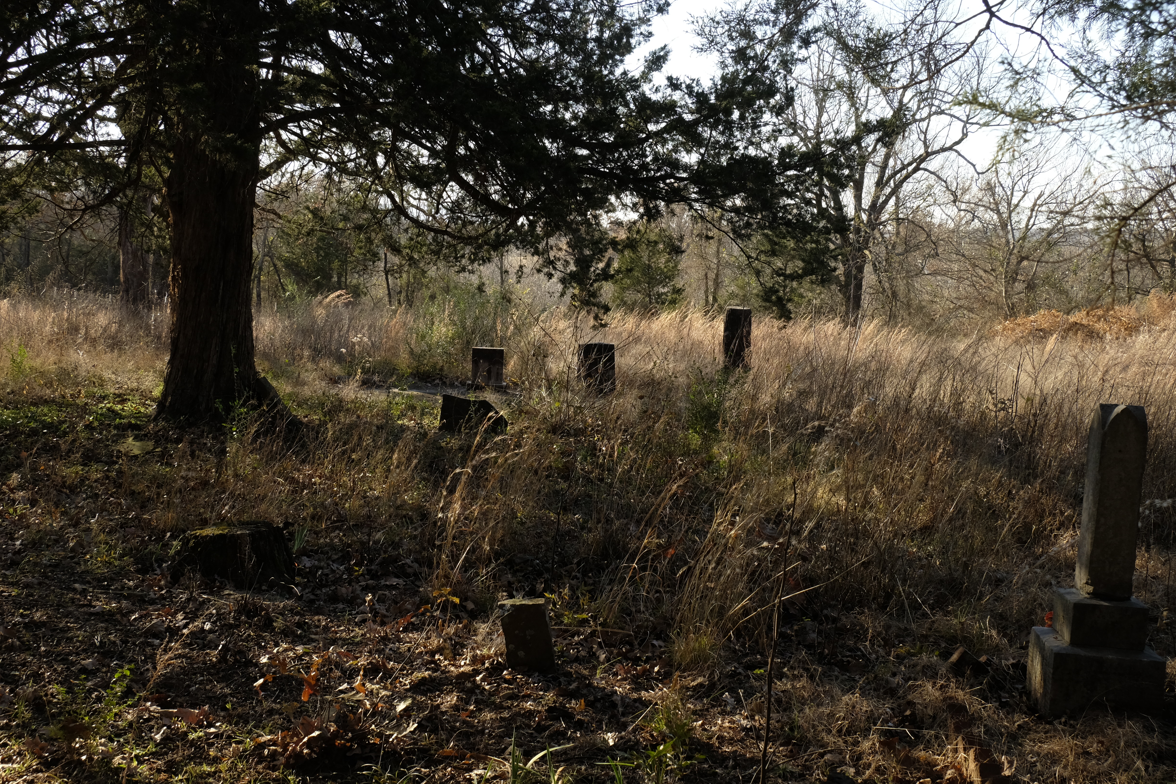
Old graves in Brazil Cemetery.
The cemetery is still in use, with recent graves near the road and countless old resting places spreading into the woods, their uninscribed stones scattered among the brambles.
“Here as in other isolated settlements, we saw many graves surrounded by a fine wall of dry stone masonry, about four feet high. We thought this was perhaps a peculiar feature of Indian graves. We were informed, however, by several Indians [of] the Indian custom to bury their dead near their own homes. We did see in many places graves or what seemed to be a private burying ground near the old home sites. Nothing seems quite so sad as long forgotten graves.” Roscoe and Margaret Conkling.
Stone grave enclosure at Brazil Cemetery, possibly the same one the Conklings photographed.
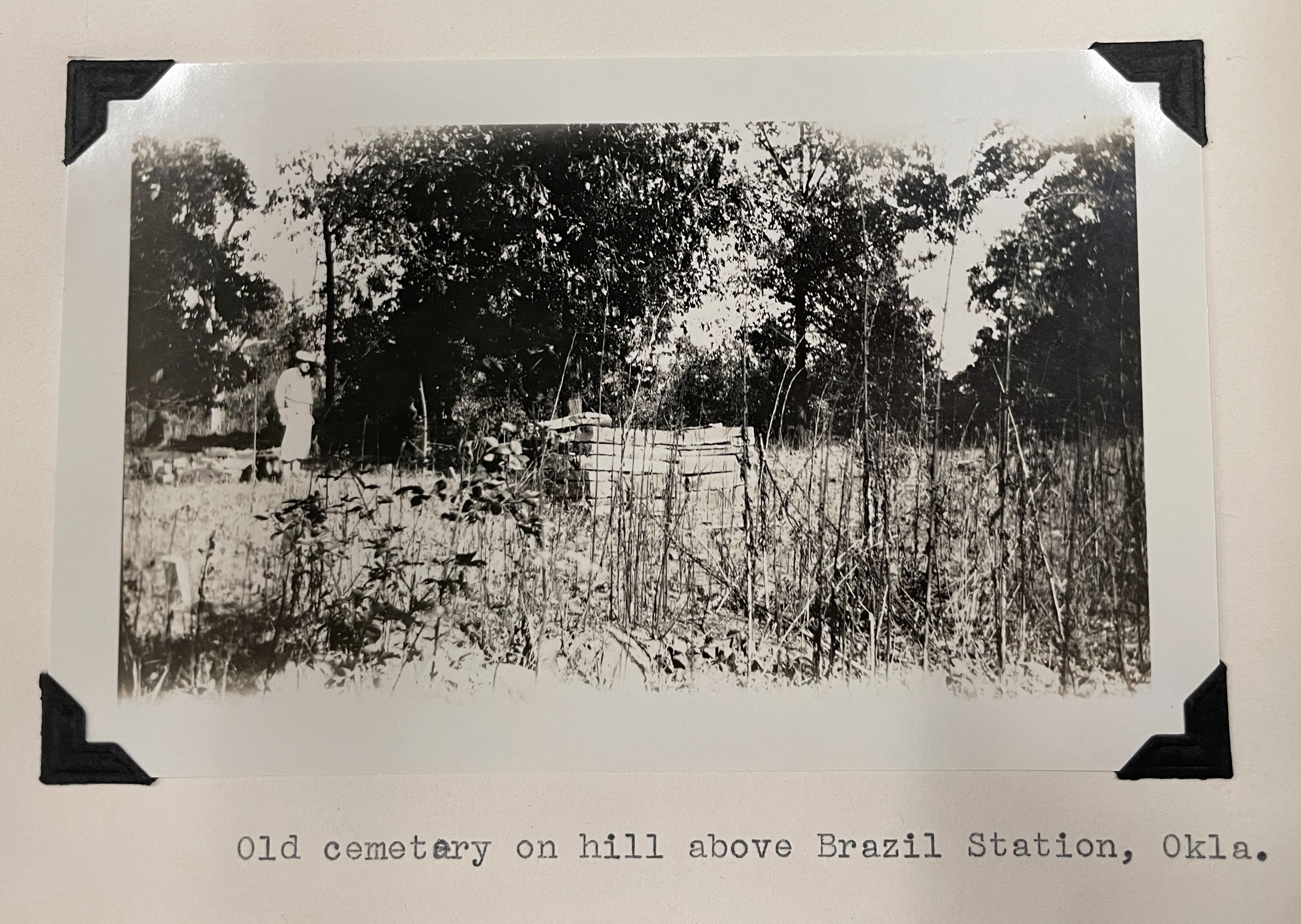
North of the graveyard, a pile of rubble that once was Brazil School hides in the trees, its clearly defined foundation enveloping the stones of the collapsed walls. About the school the Conklings wrote, “After driving all morning without meeting anyone on the road, we felt that we were in a deserted countryside. But when we arrived at Brazil School, there were perhaps thirty children out for recess with the teacher directing their play. All looked modern enough and quite happy even though their school yard was a continuation of the cemetery. Not even a fence line to protect the early graves.”[viii] By 1958 the school was abandoned.
Bill Dragoo stands amid the ruins of Brazil School.
In spite of the fact that Brazil was not an official Butterfield stop, much was written about it in in 1930 and 1958. During their visit in November 1930, the Conklings met Robert Anderson (R.A.) Welch, son of D.R. Welch. At the time, the Conklings believed Brazil Station to be a Butterfield station, as did Welch.
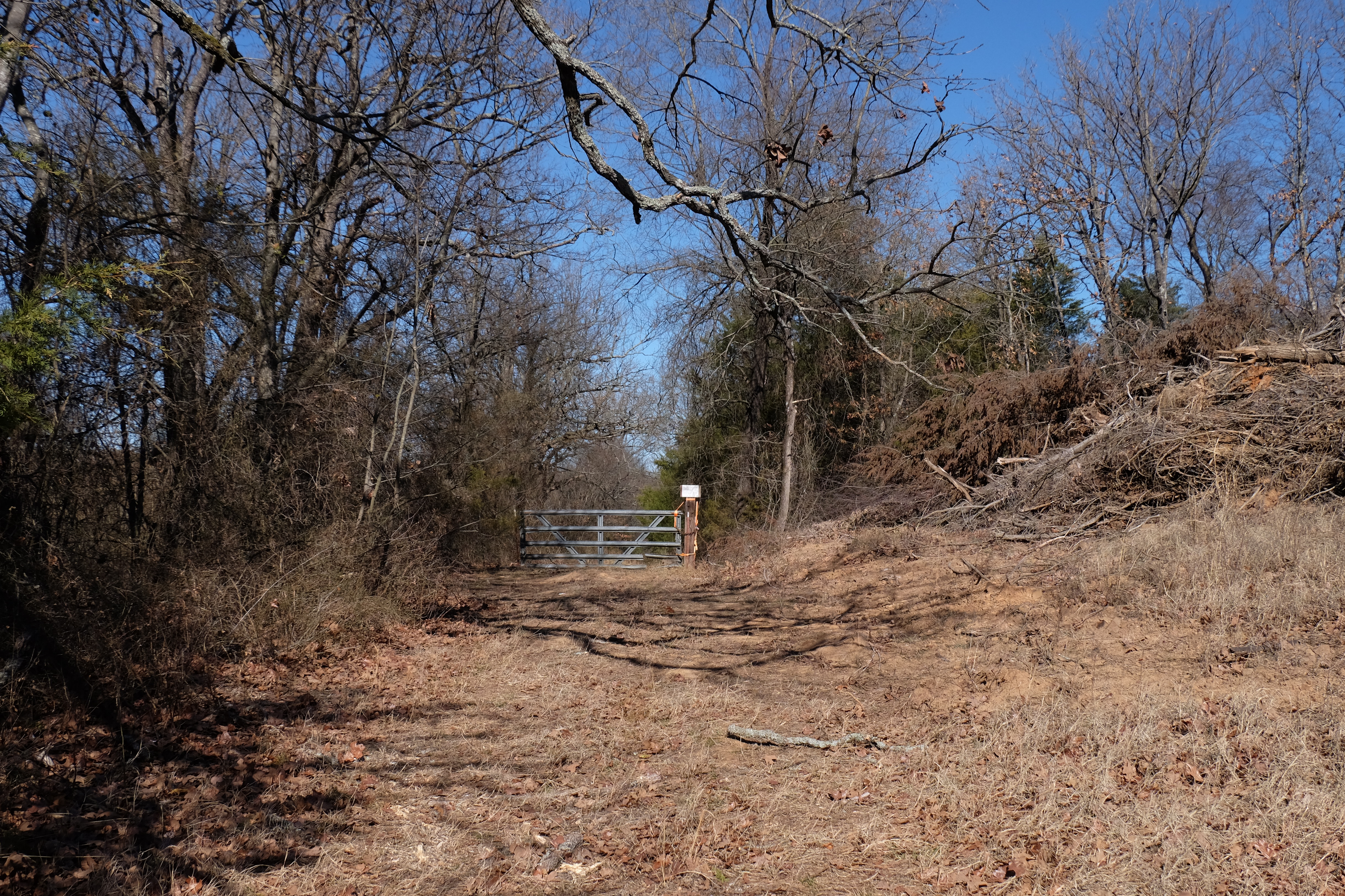
A locked gate now blocks access to Brazil Station from the south.
North of the cemetery, a locked gate now blocks access to Brazil Station. This was not the case in 1930, and the Conklings drove past the cemetery and school right up to the D.R. Welch house, near the site of the stage station. They were told the house was built in 1868.
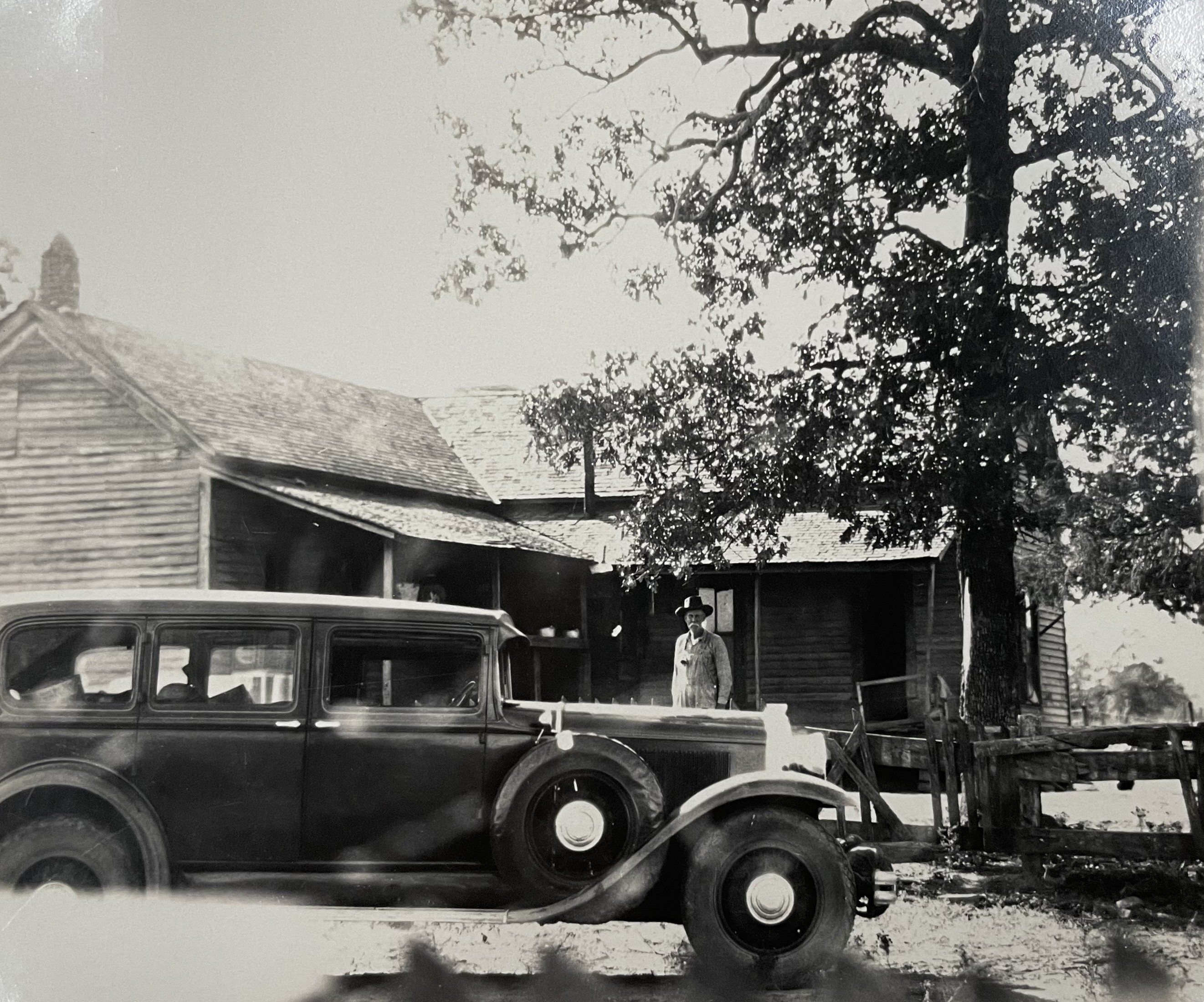
“Old house which we were told was built near site of Butterfield Stage Station, located at Brazil Creek, Okla. We found an old cemetery above this house near the present School. Near this were the ruins of a number of old buildings. Mr. Welsch (sic), whom we met later, told us that the old station was located near Brazil Creek about 1000 feet from this house.” Roscoe and Margaret Conkling. The man in the photo is possibly Robert A. Welch. The car belongs to the Conklings.Trees now grow up through the foundations of the old house at Brazil Station, possibly the one photographed by the Conklings.
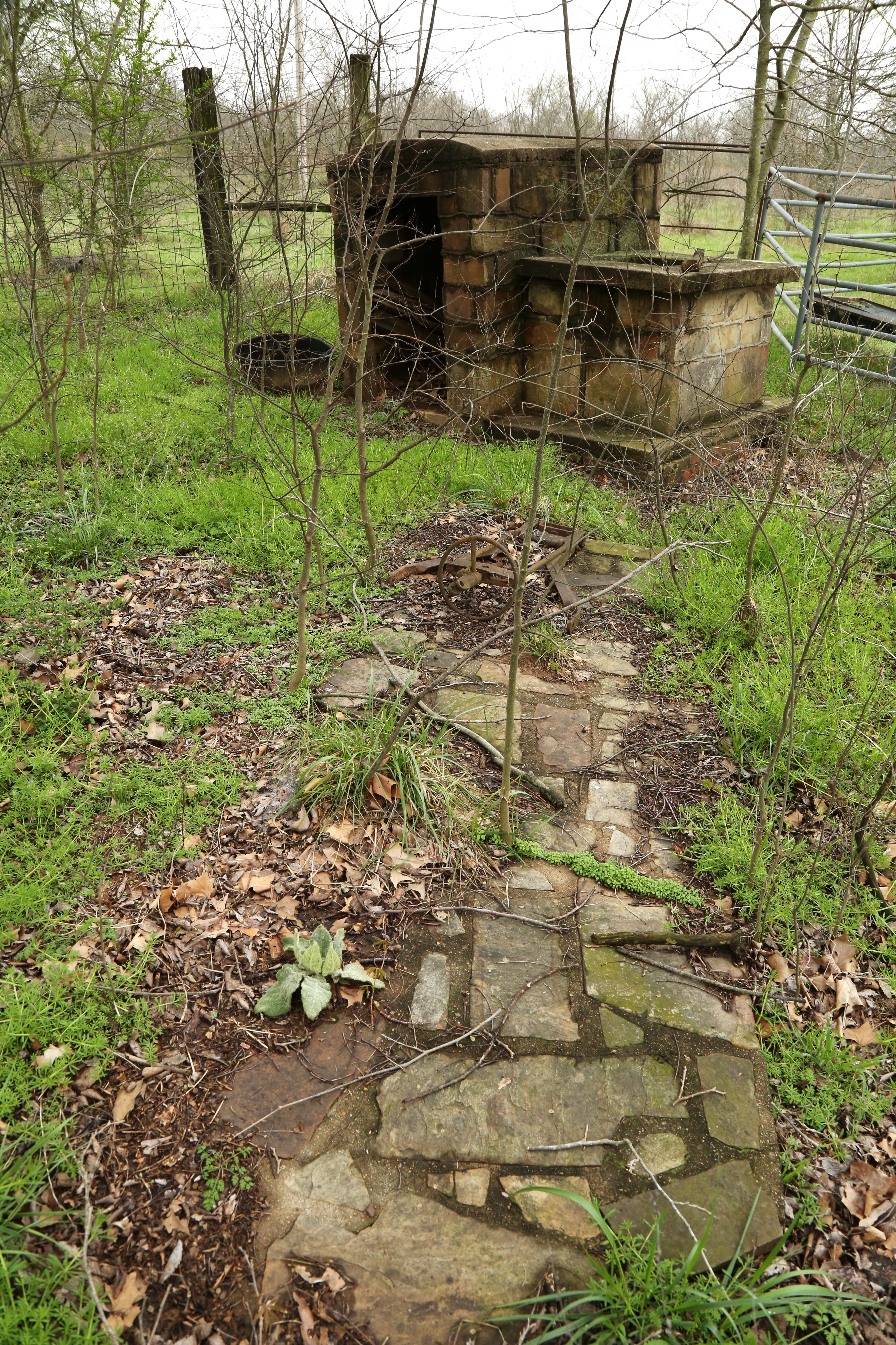
Well and sidewalk near the old house.
Welch also owned land in the Arkansas River bottom at Geary Lane, later renamed Braden. “The only way through this bottom land was by Geary Lane and as father had control of the land, he made this a toll lane,” said R.A. Welch. “However, this toll fare was only charged for the passage of people who were not citizens of the Territory and all the Choctaw Indians were allowed to go through free of charge.” The younger Welch, born in 1877 to D.R. and his third wife, Phoebe, dated the Brazil settlement’s origins to 1876, contradicting the 1868 date reported to the Conklings.[ix] In an 1885 newspaper article, however, a current resident of Brazil Station wrote that Welch established his trading post in 1872, effectively beginning the Brazil settlement then.[x] The correct date is difficult to determine, but a mention of stopping at “Daniels Station” for rest and forage in April of 1861 by William Woods Averell suggests there was a settlement here prior to the Civil War. During his short stop, Averell may have misinterpreted “McDaniel,” one of the partners who built the Brazil Creek bridge, as “Daniel.” (Source: Ten Years in the Saddle, The Memoir of William Woods Averell, 1851-1862, p. 259.) For more on Averell’s journey, see https://gateway.okhistory.org/ark:/67531/metadc2123780/
A post office named Brazil Station was established on April 11, 1879, with Phoebe Welch as its first postmaster. She was the fifth female postmaster in the Indian Territory, at a time after the Civil War when across the United States more women were being appointed to the role.[xi] When the post office name was changed to Brazil in 1895, the postmaster was Phoebe Reagan, who, we may surmise, remarried after D.R.’s death in 1892. The Brazil post office was discontinued in 1913.[xii]
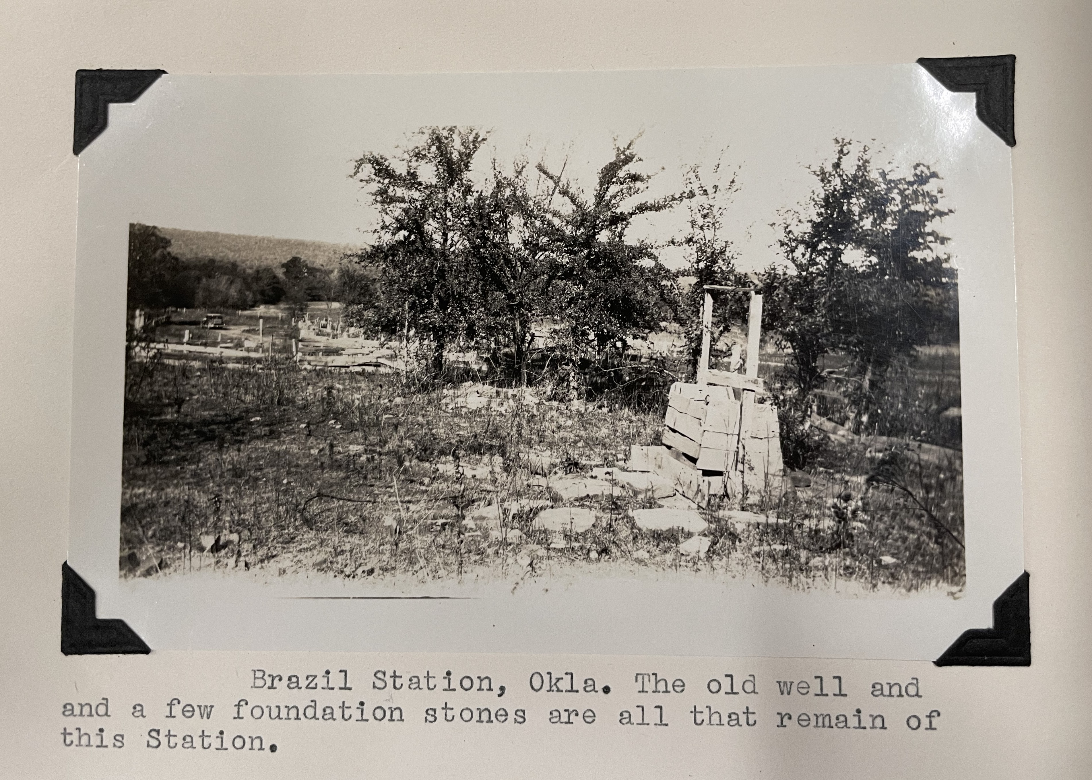
The Conklings and the Centennial Committee, led by Muriel Wright and sent out by the Oklahoma Historical Society in 1958 to identify Butterfield station locations, found the ruins of the Brazil stage station northwest of the Welch house, near the creek. The Conklings wrote, “The ruins of the old stage house are about half a mile West of the Welch house. Across the road from the Welch house are ruins of a blacksmith shop and warehouse.”
Photograph and caption of station ruins by Roscoe and Margaret Conkling. Given the location of the mountains in the background, the view may be toward the north.
The station ruins are no longer evident, but the Welch family grave plot near the house, an old well and a row of bois d’arc trees mark the site, changed little since 1958.[xiii]
A lane east of the ruins of the house leads to the locked gate blocking entry from the south, the access point for both the Conklings and the Centennial Committee. Black locust trees also observed in 1958 still flourish, their long thorns creating a hazard for the distracted walker, especially near the small cemetery.
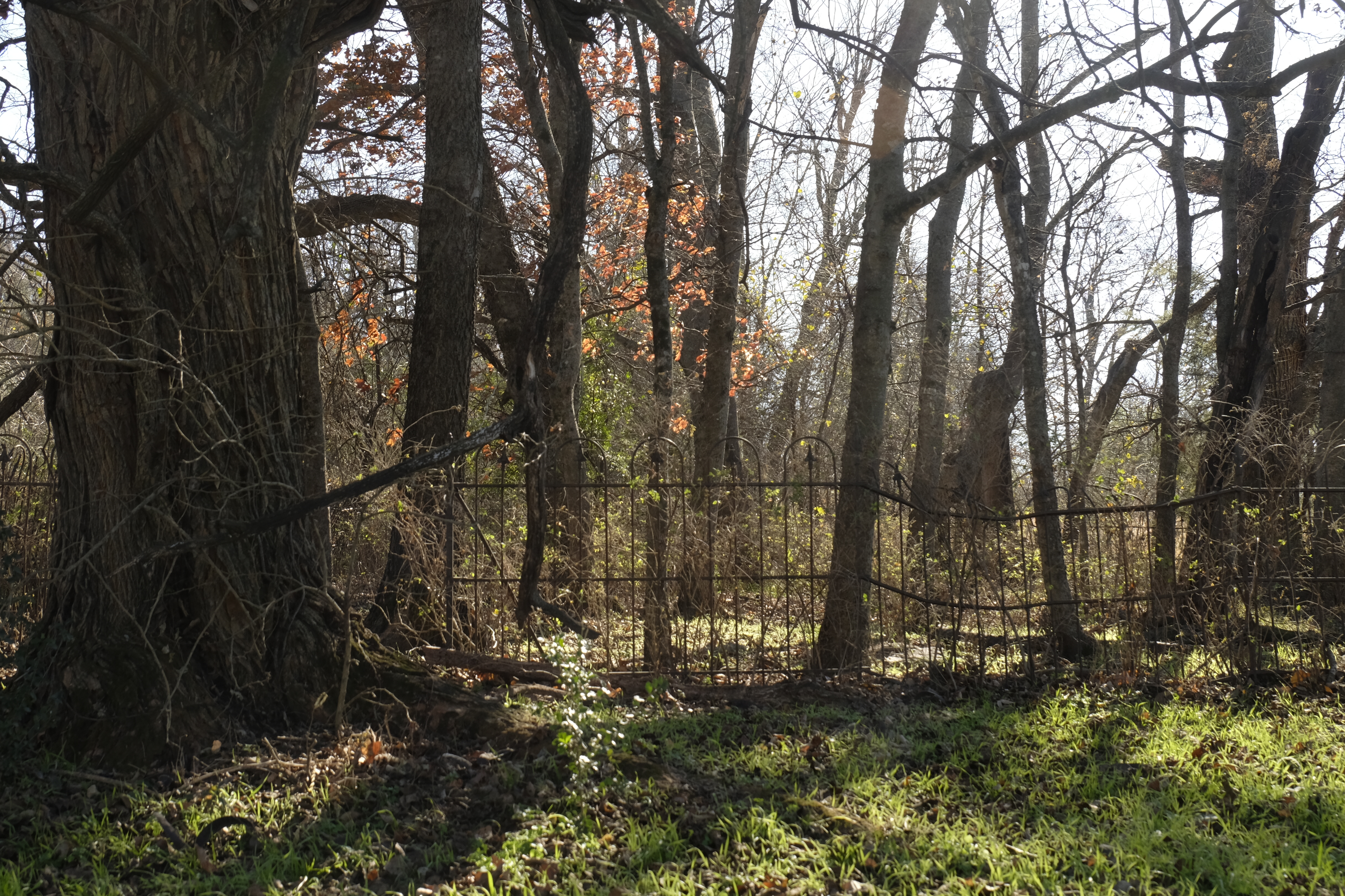
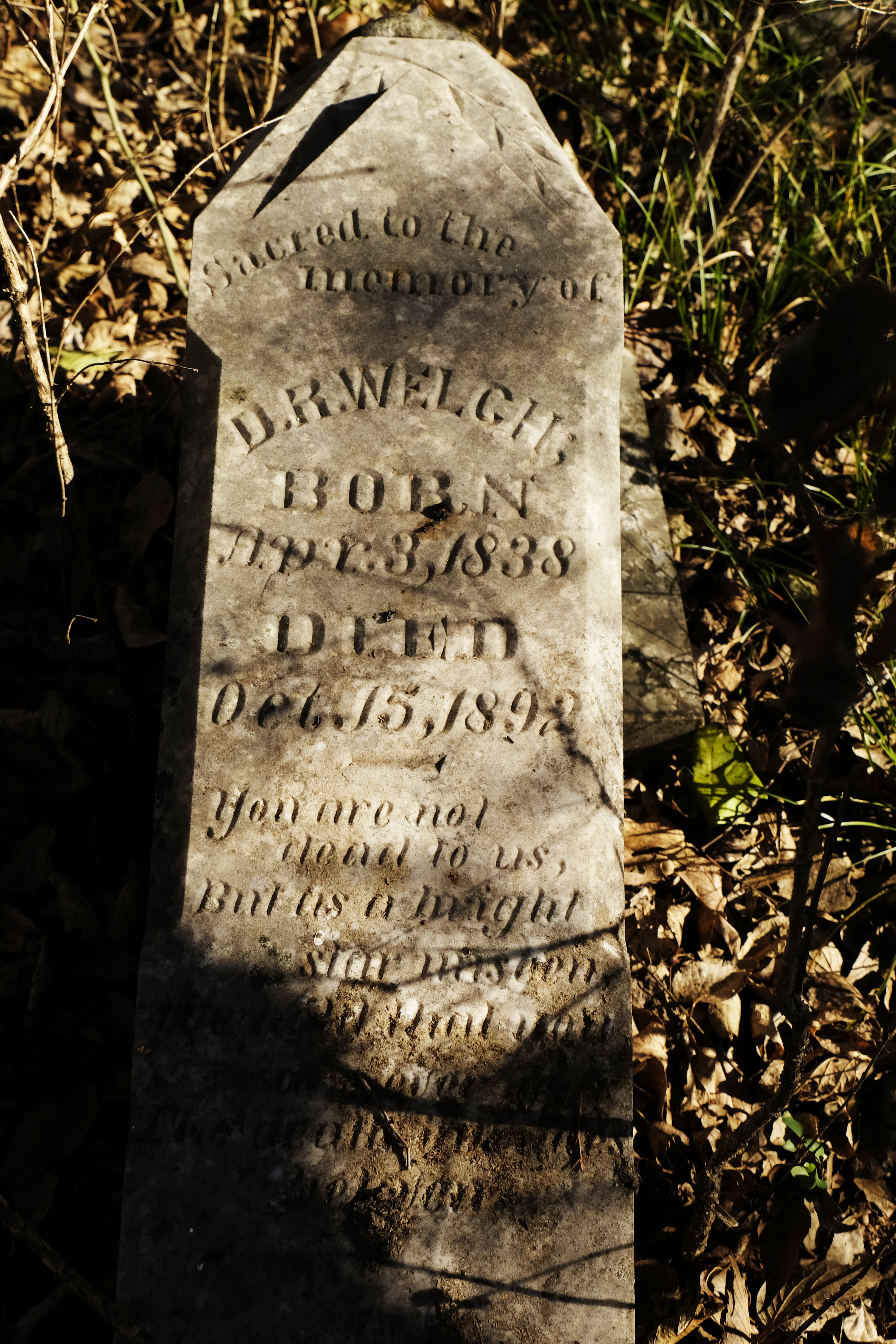
Welch family cemetery.
An ornate wrought-iron fence topped with the fleur de lis surrounds the picturesque Welch graveyard. D.R. Welch’s tombstone is in the southeast corner, broken off at the base but otherwise in good condition. The small plot contains several other markers including that of D.R. Welch’s second wife, Lucinda.
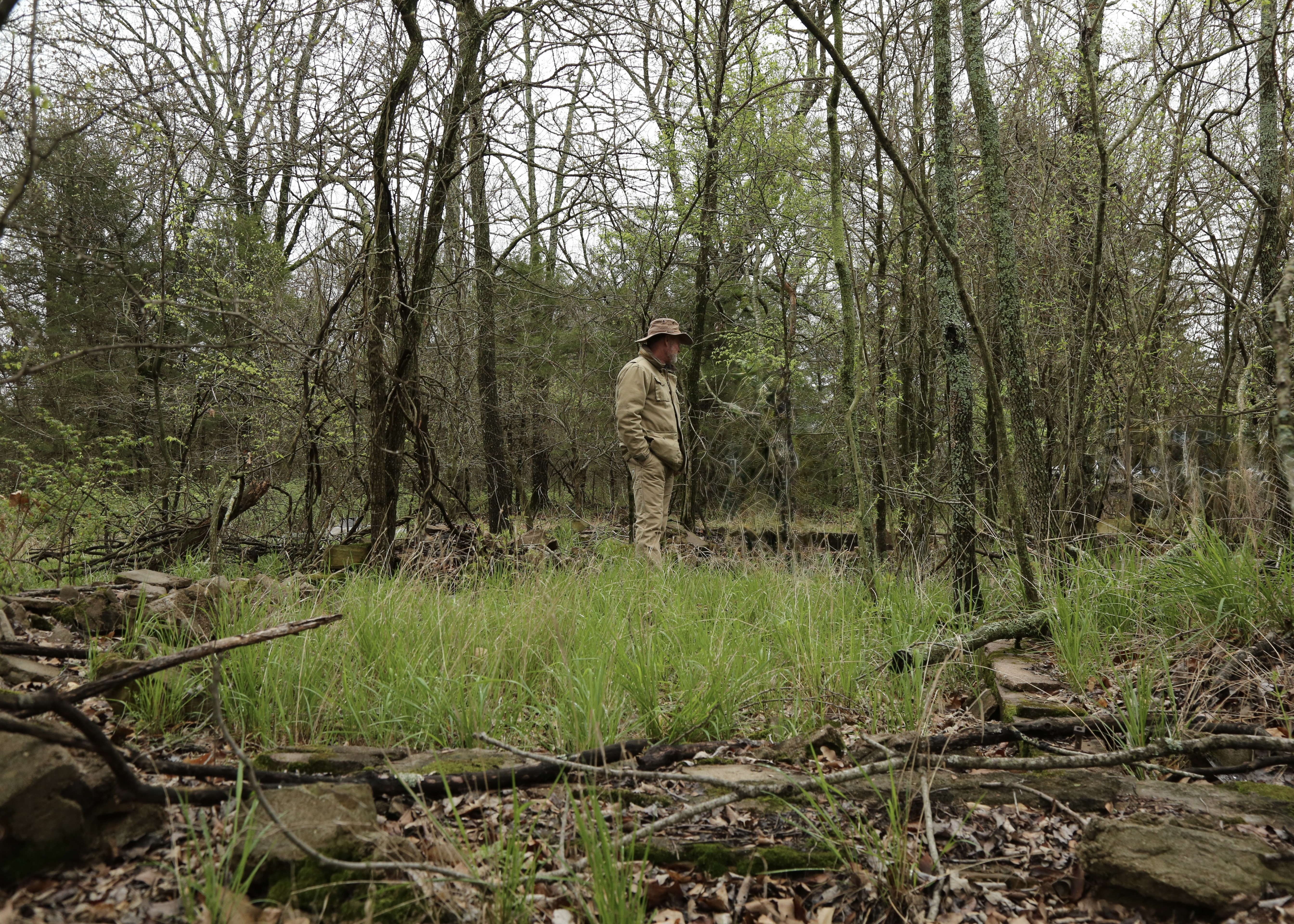
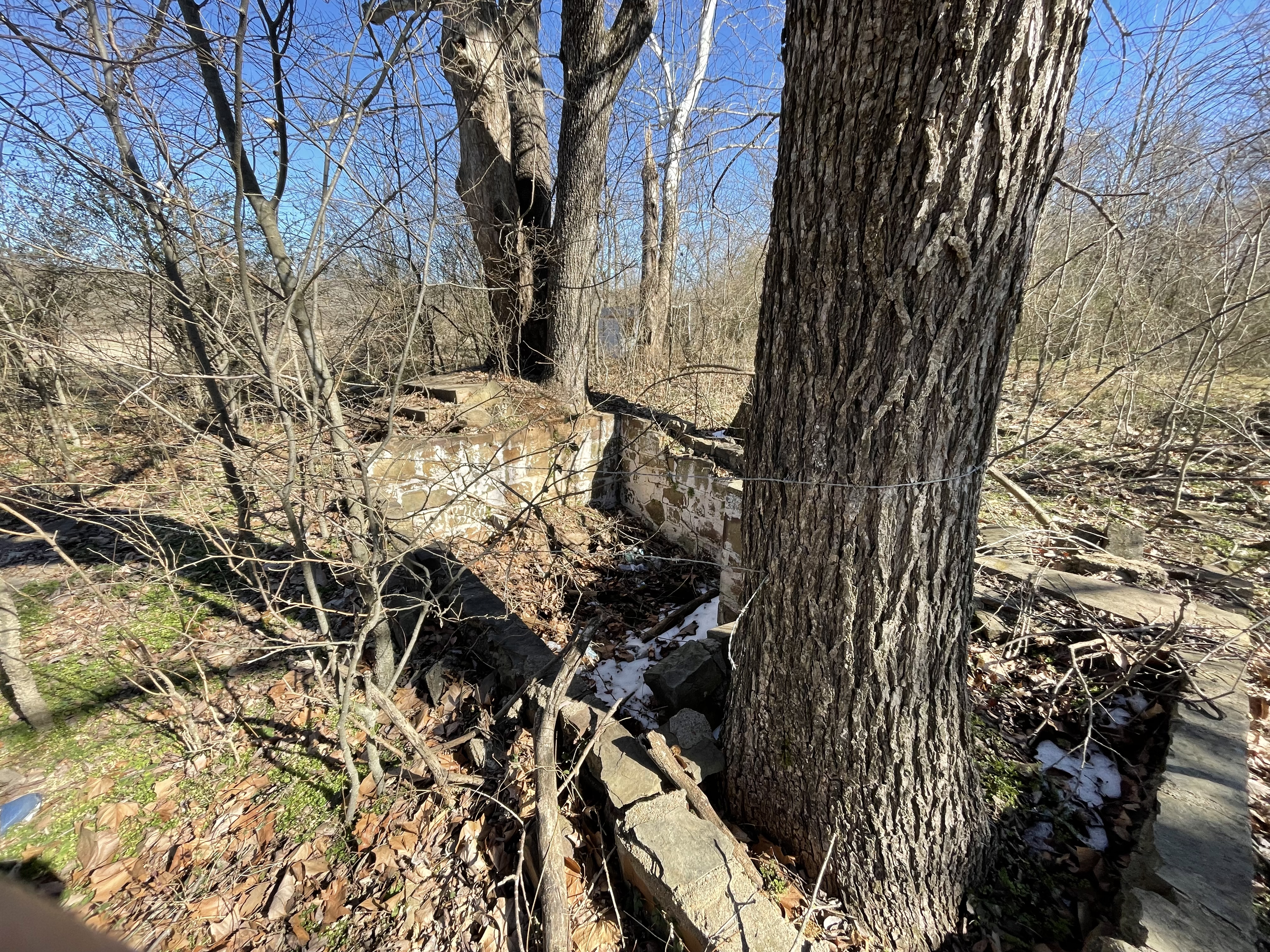
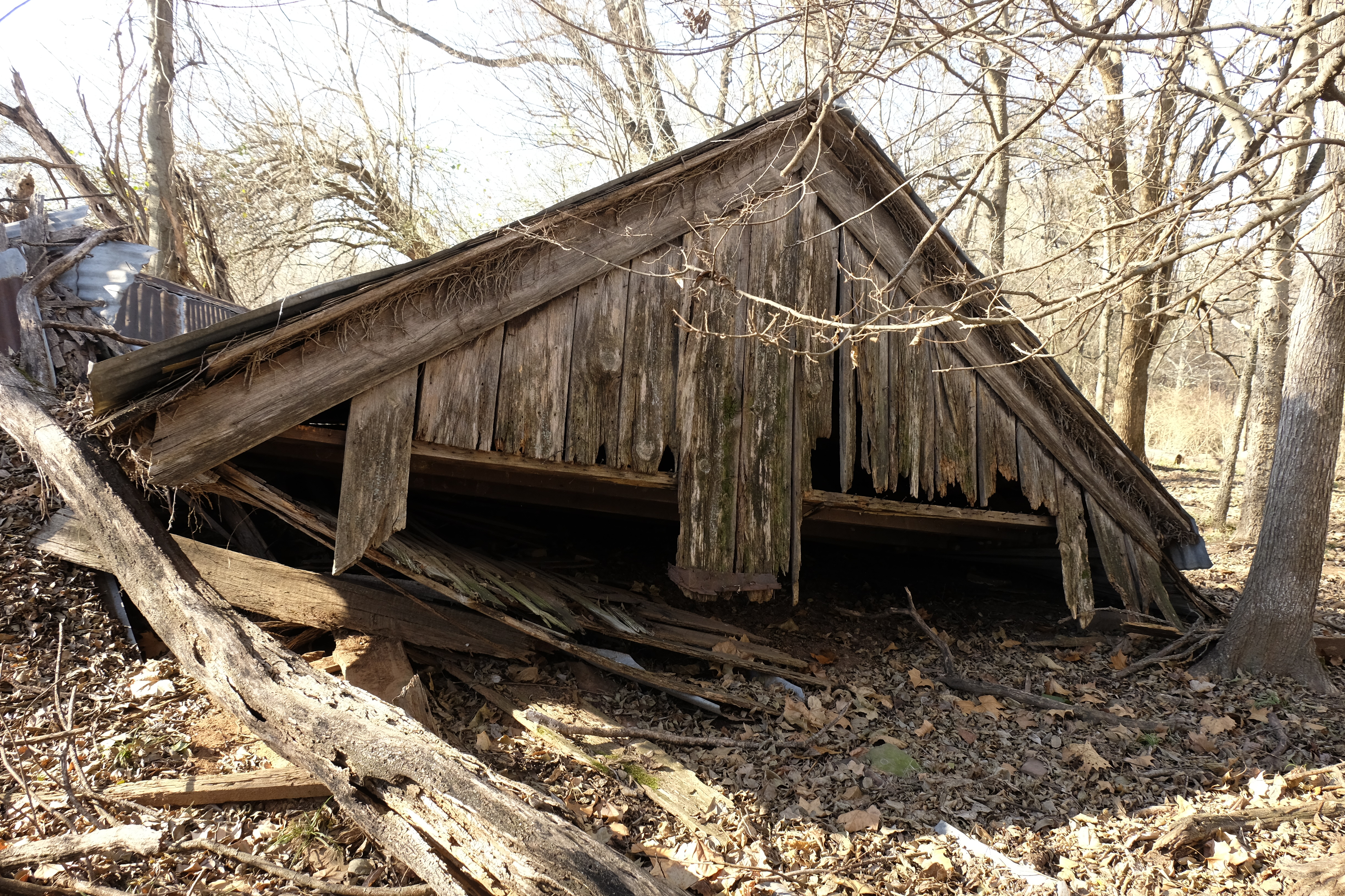
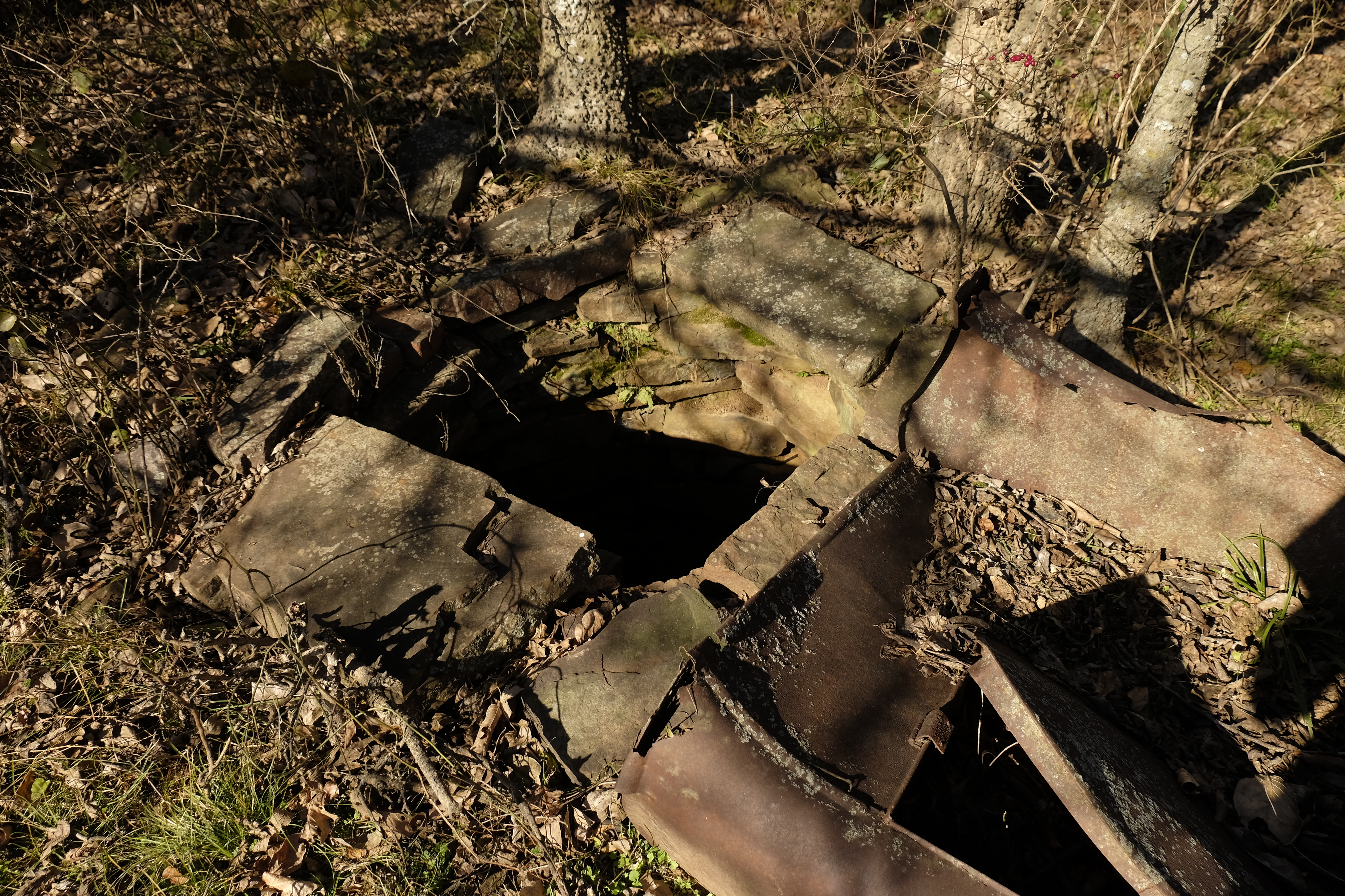
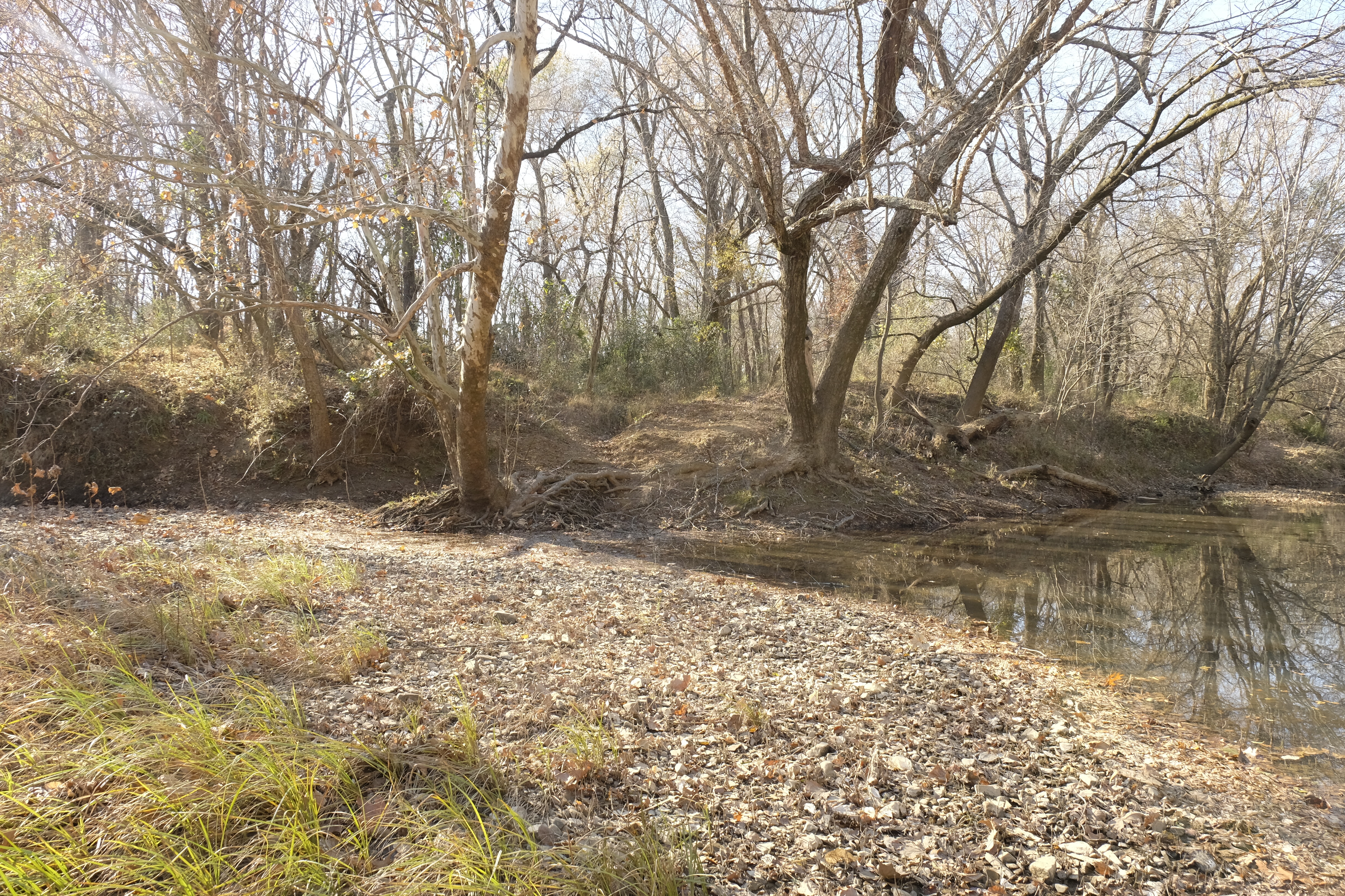
Before my site visit with Joe Wolf, I came alone and walked the mail road’s path from Brazil Station northeast to the Brazil Creek crossing. From the Brazil settlement, the trail quickly enters a deep rut flanked by large trees, the width of a narrow road. It was difficult to walk in the depression, where small trees and briers grow thickly. I crossed Mack Watson Creek, the water shallow and the rocks slippery. Continuing through a pasture, I saw an old ruin on a slight rise. Its roof had collapsed but a stone-lined well remained intact, sheltering a snake in its cool interior.
Collapsed building on the old road from Brazil Station to Brazil Creek.
Well at the ruin.
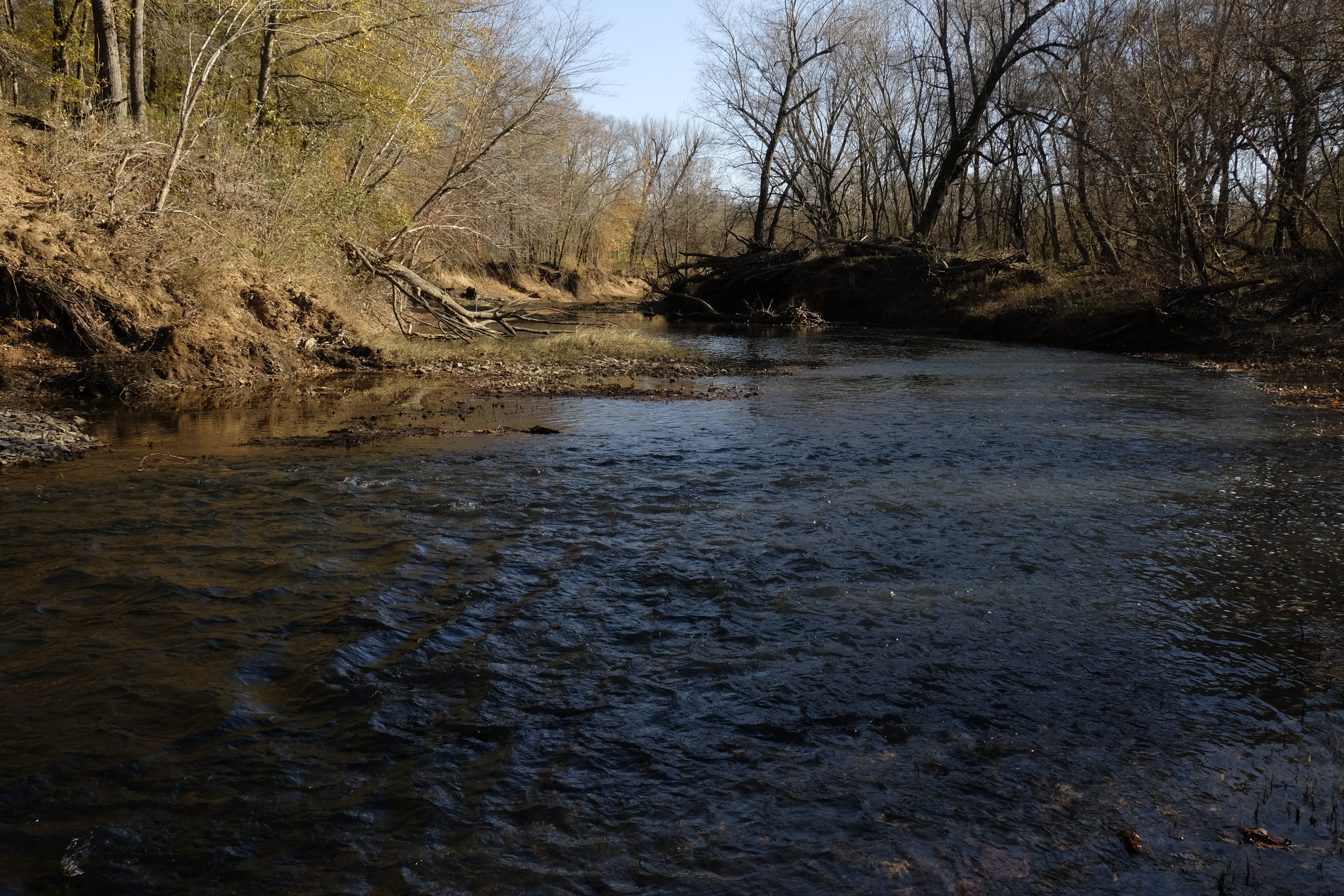
Brazil Creek at the probable location of the crossing.Possible crossing point on the western bank of Brazil Creek.
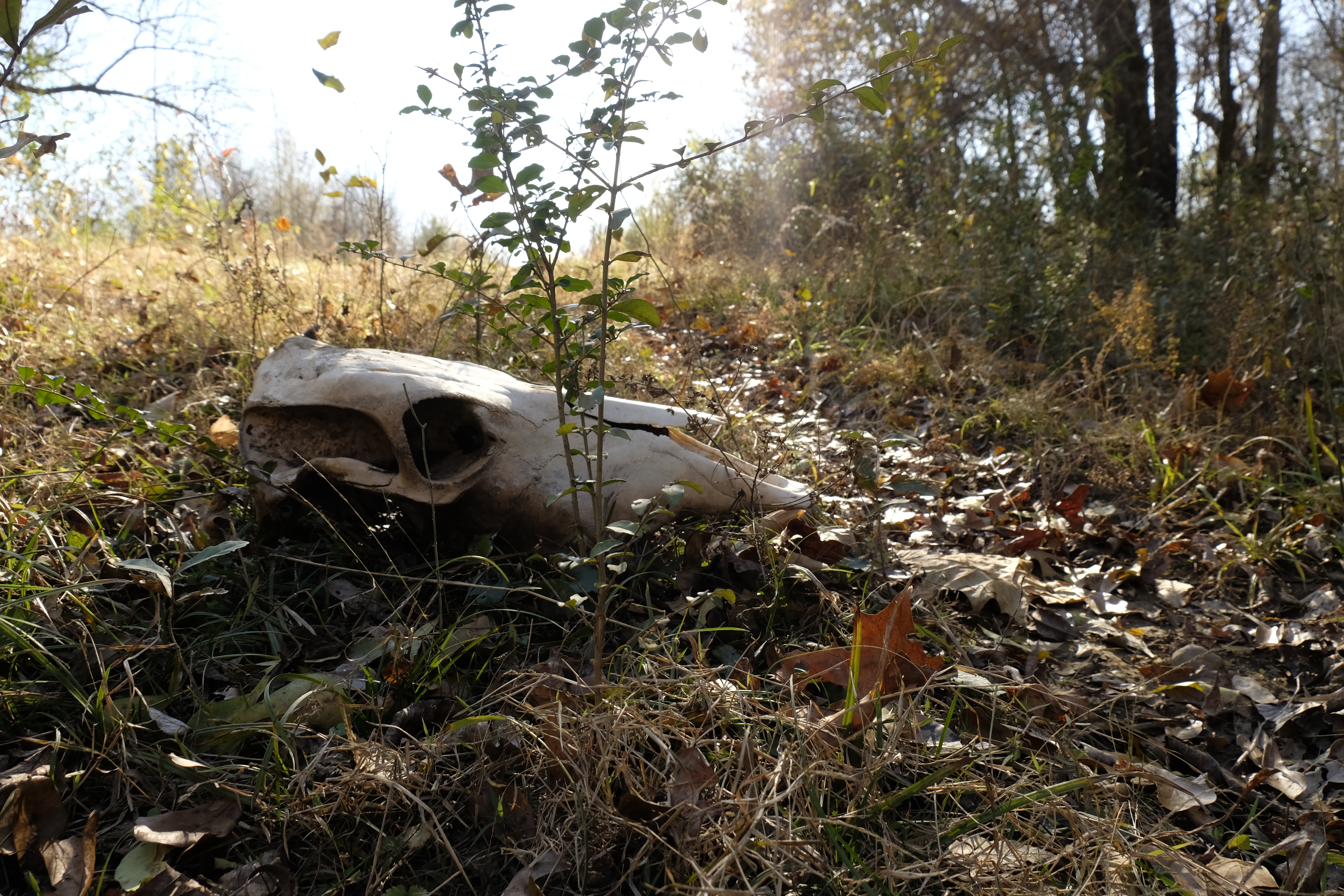
Skull in the old road just above Brazil Creek.
On a well-defined and recently used two-track, I soon arrived at Brazil Creek. A likely crossing site was evident where the creek bank is cut down on the east and a path gradually ascends from the creek on the west. The location is consistent with the crossing on a historic map, and a modern aerial view shows a road trace continuing northeast on the east side of the creek.
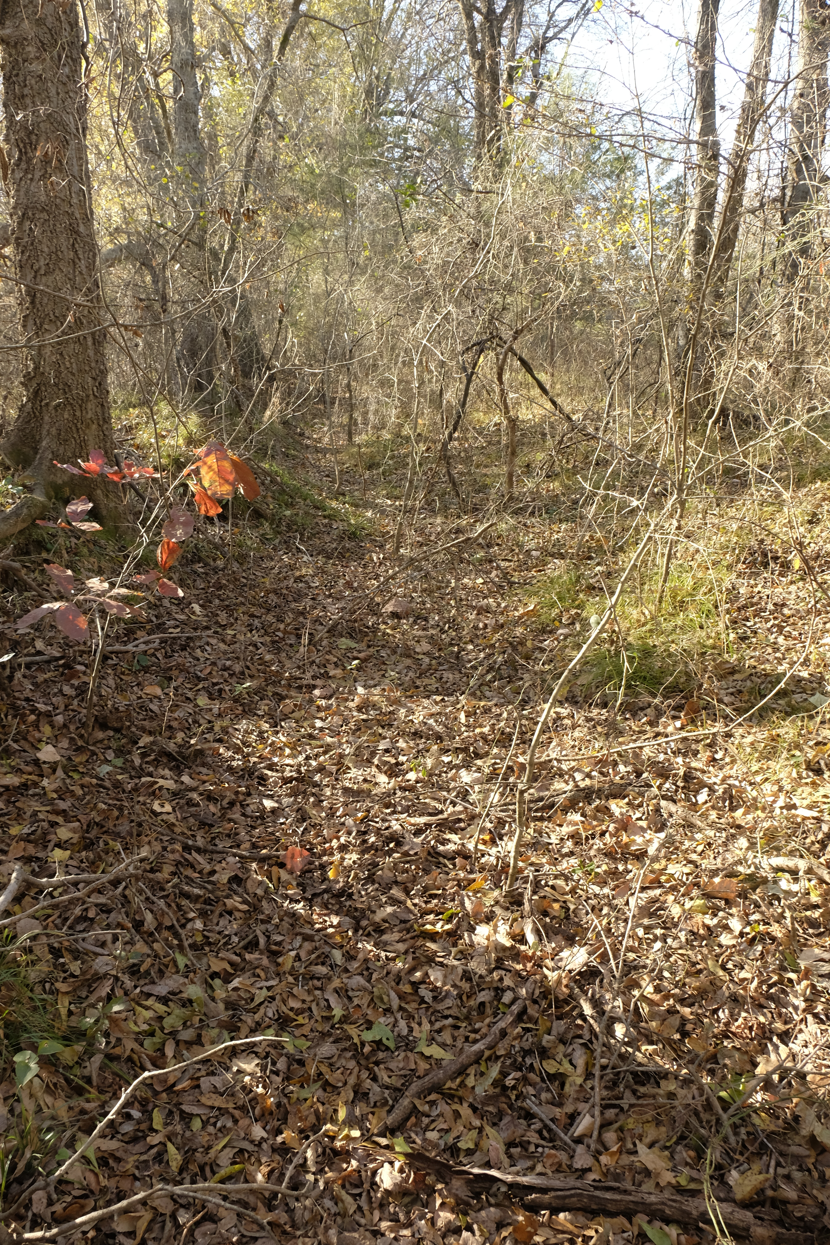
Returning from the crossing, the change in perspective made the deep swale of the old road more distinct. With increased resolve to push through the undergrowth, I walked most of the way back to Brazil Station in the trace, about a mile, detouring occasionally for incessant tangles of briers.[xiv]
Trace of the old Butterfield road at Brazil Station.
Later, as I explore the area with Joe before our encounter with the Jeep driver, a cow path beckons us around a pond southwest of the house and well. Soon we enter a depression lined with massive bois d’arcs. The swale ends at the fence bordering the county road, where the stagecoach road continues toward Trahern’s Station, the second official stop on Butterfield’s Indian Territory itinerary.
For more adventures on the Indian Territory segment of the Butterfield stagecoach road, grab a copy of my book, Finding the Butterfield: A Journey Through Time in Indian Territory, at https://a.co/2BE4p7R. Also see https://susandragoo.com/butterfield-oklahoma/ for more resources.
[i] Lula Neighbors. January 13, 1938. Indian-Pioneer Papers.
[iii] Dianne Everman. U.S. Department of Interior. National Park Service. National Register of Historic Places Inventory., Skullyville County Jail, Choctaw Nation,80004286. April 21, 1980, 2-3.
[iv] Izora James. May 27, 1937. Indian-Pioneer Papers.
It is possibly the world’s best-known gospel song and was designated Oklahoma’s official “state gospel song,” in 2011. First popularized in the early 1870s, “Swing Low, Sweet Chariot” emerged from the pre-Civil War cotton fields of southeastern Indian Territory. Or did it?
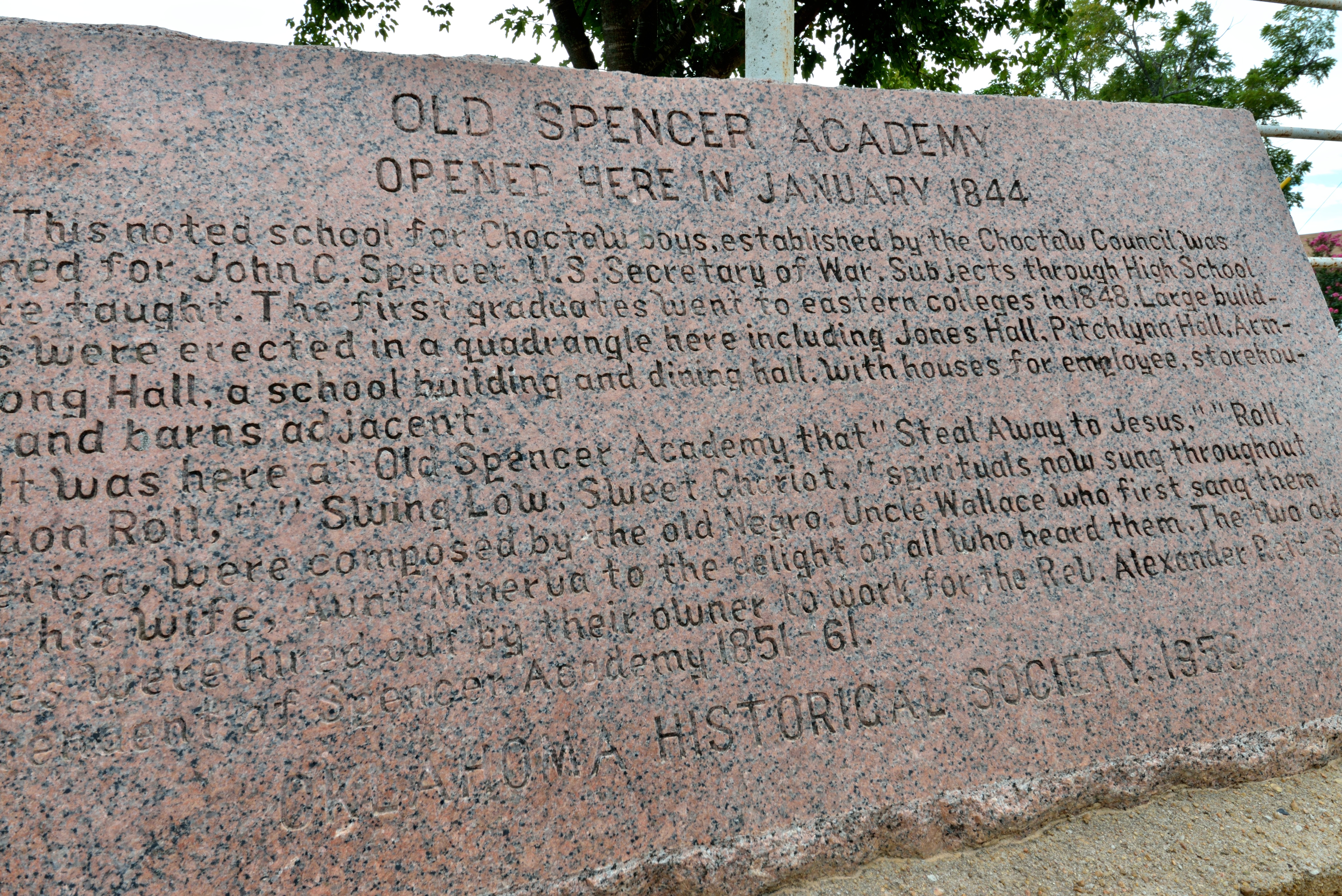
As the story goes, an enslaved man, “Uncle Wallace” Willis, composed the song before the Civil War while working the fields in southeastern Indian Territory, now Oklahoma. “Aunt Minerva,” an enslaved woman who worked by Wallace’s side, has been assumed to be his wife. The two were “rented out” by their enslaver to work at Spencer Academy, a Choctaw boarding school located about ten miles northwest of Fort Towson.
Historical marker at the site of Spencer Academy. Photo by Susan Dragoo.
Reverend Alexander Reid, superintendent of the school from 1849 to 1861, heard the pair singing “Swing Low” and other spirituals. In 1871, Reid attended a concert by the Jubilee Singers of Nashville’s Fisk University, and thought the Willis songs better than those the Jubilee Singers were performing. After the performance he passed the songs along to the Fisk group, which introduced them to the world.
But there is another version of how “Swing Low” came to the Jubilee Singers and ultimately to great fame. And other mysteries linger. Click on the link below to read my article on the subject from the January/February 2015 edition of Oklahoma Today magazine.
Supplying another piece to the puzzle of the photographs missing from the Fisk University library, here’s an excerpt from correspondence with Dr. Toni Anderson, author of the 2009 book, “Tell Them We Are Singing For Jesus”: The Original Fisk Jubilee Singers. Anderson shared the following excerpt from an article in the Fisk News, vol. VII, no. 1, Nov/Dec. 1934. It is an address given by Dr. Georgia Laura White, the daughter of George L. White, at one of Fisk’s Jubilee Day observances. In speaking of those who contributed spirituals to the Jubilee Singers’ repertoire, she states:
“There were many contributors whose names will never be known. I have asked to pay tribute to one which is symbolic of many others. One night after a concert an old man came up and said he enjoyed the concert so much. “But there is one song the people in my section sing that you did not sing and I would like to give it to you,” he said. He gave them the words and hummed and whistled them with Ella Sheppard at the piano and Mr. White with the violin. They took the song and when he had finished they had “Steal Away.” The minister’s name was Rev. Alexander Reid, Presbyterian missionary to the Choctaw Indians. He said he knew of the Negroes stealing away across the river. So I wish to present this picture to Fisk University in honor of those who contributed and are unknown.”
Alexander Reid. Source: Gateway to Oklahoma History
More recently, R.B. Ward, a descendant of Wallace Willis, published an article in the Chronicles of Oklahoma clarifying the relationship between Wallace and Minerva Willis. In the Spring 2022 edition of the journal, Ward provides evidence that Wallace and Minerva were actually father and daughter, not husband and wife. Read the article here:
The story of Uncle Wallace and Aunt Minerva has been shared many times over the years, becoming something of a legend. Ward’s insight into the lives of her two ancestors enriches and demystifies an important and fascinating chapter of Oklahoma history.
In 1860, an eastbound stage of the Overland Mail carried Eadweard J. Muybridge, traveling as a through-passenger from San Francisco, from whence he had departed July 2. Best known for his use of photography to capture animals in motion for the first time in 1878, Muybridge laid the groundwork for modern motion pictures through innovations including the shutter system to stop motion and one of the earliest motion picture projectors, the “zoopraxiscope.”
Eadweard J. Muybridge
But in 1860, he was an English book seller who had been living and working in San Francisco. Muybridge was traveling to the east coast and eventually to England. On Friday, July 20, the stagecoach met with an accident when the horses ran away on the descent of a hill. The wagon left the road, collided with a tree and was smashed to pieces. Muybridge sustained a serious head injury and a passenger with the last name of Mackey was killed. Everyone on board was injured.
As far as is known, this was the only stagecoach accident, or any other kind of incident, fatal to a passenger during the two and one-half year life of the Overland Mail line on the southern route, 1858-1861. Newspapers reported that the accident occurred at “Mountain Station.” This has been interpreted by some historians and Muybridge biographers as “Mountain Pass Station,” located on the Overland Mail route near Merkel, Texas, seventeen miles west of Abilene, about 250 miles southwest of Sherman, Texas, and nearly 500 miles from Fort Smith, Arkansas. A careful study of the geography and realities of transportation and communication in conjunction with the timing of events leads to a different conclusion, however.
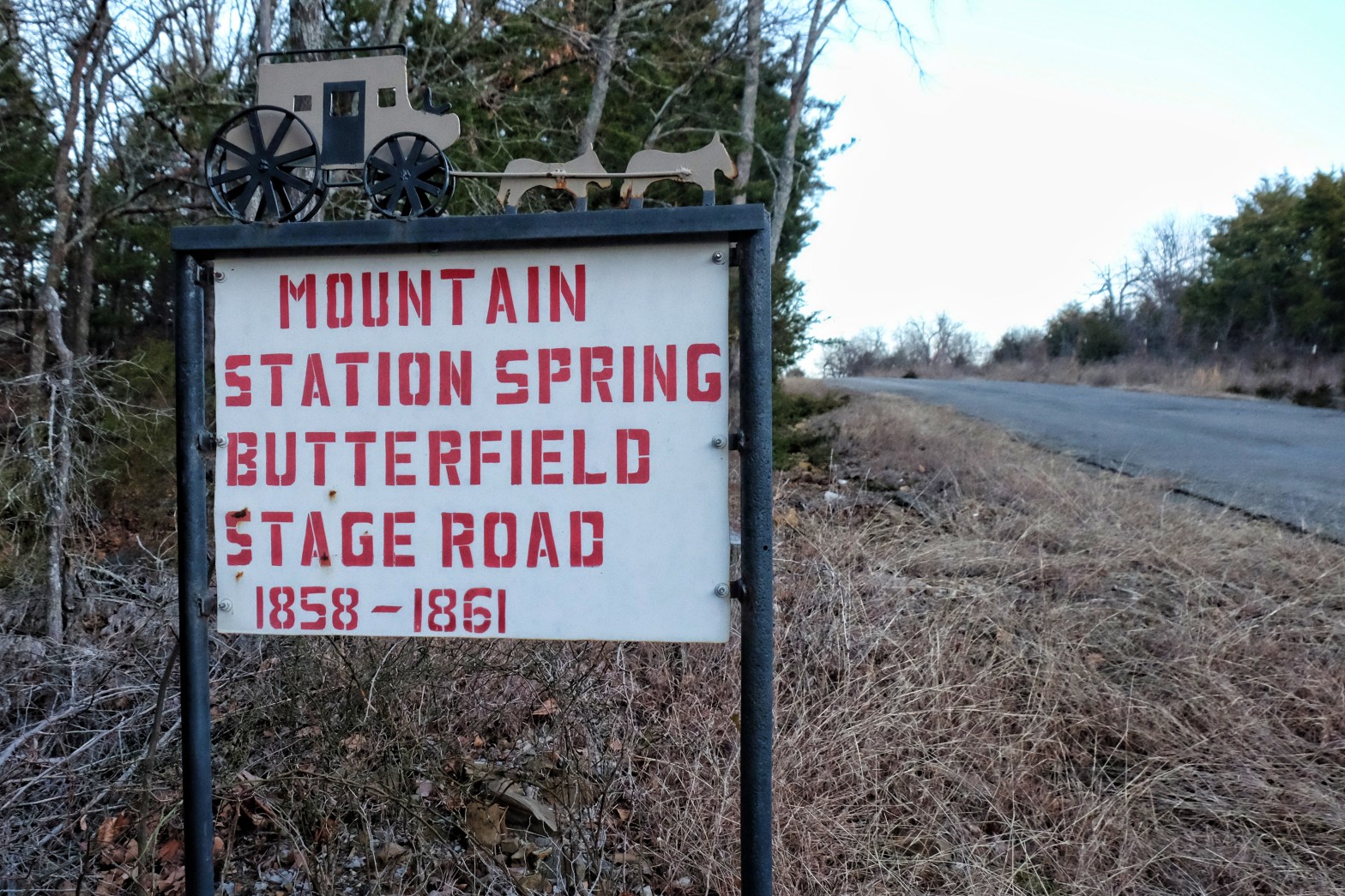
Mountain Station, Indian Territory
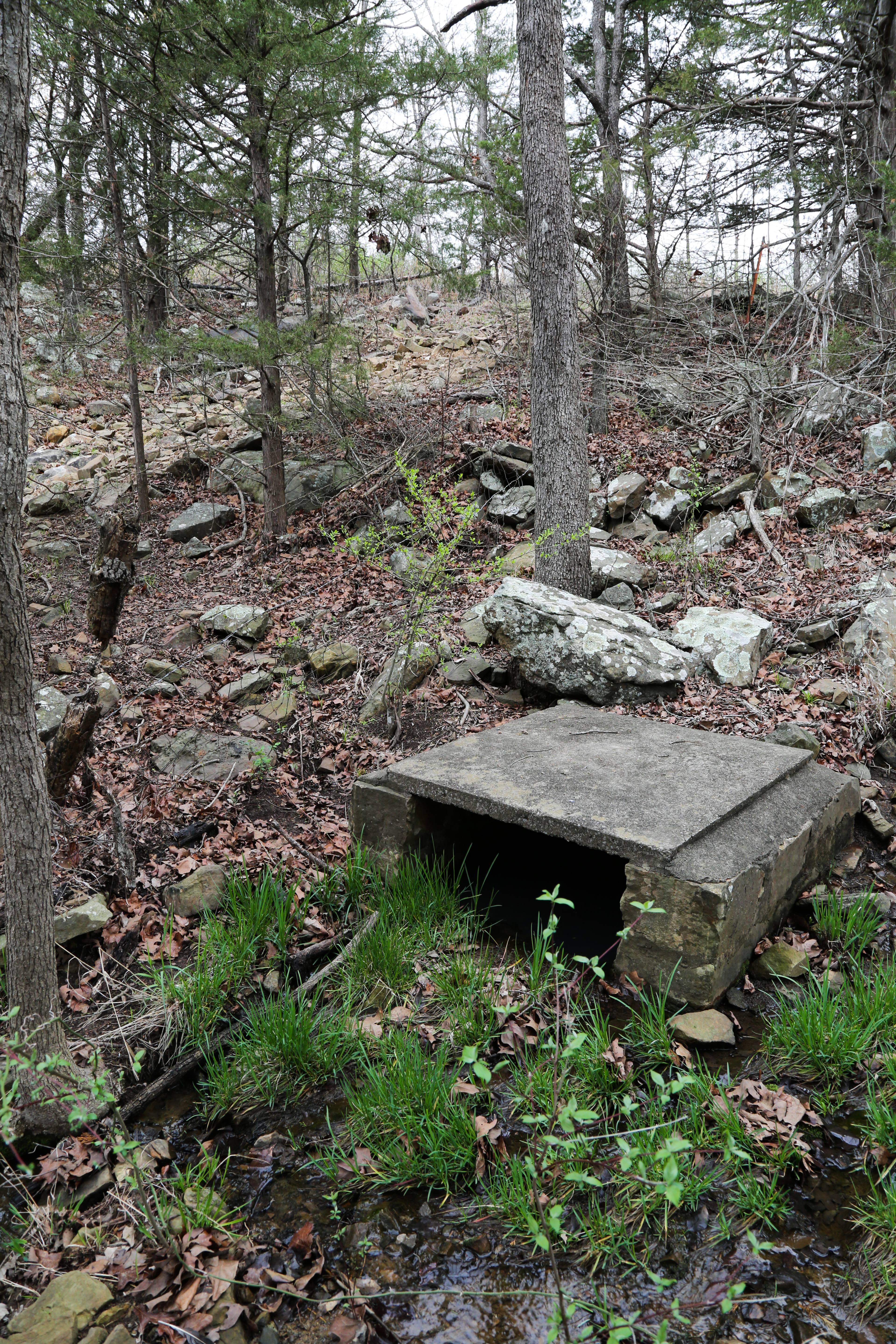
Although on at least one occasion Mountain Pass Station in Texas was referred to as “Mountain Station” in a newspaper report, there was another Mountain Station along the Butterfield route. A small relay station, it sat atop Blue Mountain in the Choctaw Nation between Riddle’s and Pusley’s, two of the twelve official Butterfield stations operated by Choctaw and Chickasaw citizens in the Indian Territory. Mountain Station was about 97 miles southwest of Fort Smith, Arkansas, in what is now southeastern Oklahoma. After the Civil War it was a well-known station on a later stage line, serving as a stop for watering horses and passengers, it being “hard driving over the rough road” on Blue Mountain. “The stages stopped at this place to water their horses and all who were aboard,” said old-timer William Dellwood Fields in 1937. In the words of another pioneer, “There was a stone house built over this great spring and part of the rocks are still there and the spring is still running today.” Another reported his father operated the trading post at Mountain Station for three years, and there was “lots of good water in a large spring there.” The spring is still flowing today near the crest of Blue Mountain.
The spring at Mountain Station is now covered with a concrete shelter. It is still flowing.
Muybridge’s Testimony
Conclusions that the accident occurred in Texas seem to be based primarily on Muybridge’s testimony fifteen years after the accident. While on trial for the killing of his wife’s lover, Muybridge recollected that on his eastbound stagecoach journey he had dined at a stage-house, then boarded the stage, which was drawn by six wild mustang horses. “That is the last I recollect of that nine days,” he said. “After that, I found myself at Fort Smith, 150 miles distant, lying in bed.” He was treated for his head injury in Fort Smith before traveling on to New York, where he continued under the care of a physician. Muybridge sued the Butterfield company for $10,000 in damages from the accident but settled for $2,500.
Although Muybridge claimed no memory of the accident himself, he relayed that a fellow passenger told him the stage had traveled about half an hour and they were just then entering the Texas Cross Timbers. “Just as we were getting to the Timbers I remarked that the best plan would be for us to get out of the back of the stage, because I saw that an accident would take place. He told me that I took out my knife to cut the canvas back of the stage, and was preparing to leave when the stage ran against either a rock or a stump and threw me out against my head.”
Muybridge’s mention of the Cross Timbers is noteworthy. The western edge of Texas’ western or “upper” Cross Timbers (because they are higher in elevation than the eastern Cross Timbers) lies just east of the Mountain Pass Station area. The claim that upon awakening Muybridge found himself in Fort Smith, “150 miles distant,” conflicts with his testimony about the accident occurring in the Texas Cross Timbers near Mountain Pass Station, which is more than 450 miles from Fort Smith. Other inconsistencies in his testimony affirm that he had no memory of the accident and was relying on what he was told by another passenger, fifteen years later.
The recounting of the incident took place in support of an insanity defense in Muybridge’s murder trial. He was found not guilty, although insanity was not cited as the basis of the verdict. Rather, the jury believed the killing justified. Still, some believed that the long-term effects of the head injury led to significant abnormalities in his personality. “Prior to his accident,” testified a close friend, “Muybridge was a good businessman, genial and pleasant in nature; but after the accident he was irritable, eccentric, a risk-taker and subject to emotional outbursts.” Following his acquittal, Muybridge went on to achieve renown in the world of photography. The head injury did not appear to inhibit his intellectual or creative achievements; rather, some have speculated it may have actually enhanced his creative abilities because he became more willing to take risks, and pursued his art obsessively.
Muybridge’s stop-motion shutter images of Leland Stanford’s horse
News of the Day
The notion that the accident occurred in Texas is difficult to support given contemporary newspaper accounts stating the accident occurred in the “Choctaw Nation” and “Choctaw Country.” On July 23, 1860, the telegraph line had just been put into operation at Fort Smith, with dispatches about the accident going out to newspapers around the country. The New York Times reported that a July 21, 1860 dispatch from Van Buren, Arkansas announced an accident to the Overland Mail coach, which was expected to delay the arrival of the mail about thirty hours. The horses, it said, ran away in the mountain pass of the Choctaw Nation. Another newspaper report directly quotes a passenger on the stage, S.P. Nott, of Sherman, Texas, also referring to the accident’s location in “the Choctaw country.” Nott’s is the most detailed account of the accident identified by this author. The newspaper item states the following:
” . . . Fifty miles from this place, in the Choctaw country, on Friday night last, the stage arrived at the station a little before sundown, and after getting supper it was about eight o’clock when the stage started, with eight passengers, Mr. Stout, road agent, and the driver. The brake was out of order, and one of the horses was refractory, and the team started in a run, but was soon checked, and Mr. Stout got upon the seat with the driver, and the latter gave his whip a crack, and away went the team down the hill full tilt, and as the brake was useless, there was no way to stop them. While the stage was at the top of its speed, the curtains being down, Dr. Denton took out his knife and cut them, and jumped out, and in cutting the curtains, cut Mr. Nott severely in the back. Dr. Denton was badly bruised in the fall.
The stage soon after struck a tree and smashed to pieces, and the fore wheels became disengaged, and the horses ran some distance, dragging the driver and bruising him severely. Mr. Nott says he braced himself, and when the stage struck the tree he landed some distance from the place where it struck, and the top of the stage with him. In recovering he heard the groans of the wounded, and on going to one he found the blood gurgling in this throat, and it being dark, he raised him up, and receiving no answer from him, he put his hand to his head and found the forepart of the skull broke in. The man proved to be Mr. Mackey, of Cass County, Missouri. He was killed immediately. Mr. Nott returned to the station and there he soon fainted from the loss of blood. Mrs. Chapin, the lady of the house, had all the wounded bodies taken to the station, and went to work and dressed their wounds with her own hands. Mr. Nott speaks in the highest terms of the kindness of Mrs. Chapin.
Mr. Stout, the road agent, was seriously injured, his face badly bruised, and his upper lip cut through, and the lower lip is not in much better condition, besides his bruises in the chest are very serious. Most of the passengers were injured more or less, and only two of them, young men from Ohio, were able to walk about. The names of the passengers are Messrs. Nott, McCarty, Halsey, Denton, of New York, and two young men from Ohio, and Mr. Mackey, of Missouri, who was killed.
On Saturday, about eleven o’clock, an express arrived here with the news of the accident, and a coach was dispatched immediately, taking Doctors Bomford and Dunlap, to attend to the wounded.
This is the first serious accident to the stage in the region of this place, since the Overland Line went into operation.”
The Mrs. Chapin to whom Nott refers would have been Martha Riddle Chapen or Chapin, daughter of John Riddle, keeper of Riddle’s, a Butterfield station thirteen miles east of Mountain Station. Martha and her husband, William Chapen (Chapin), operated Mountain Station “a few years after its establishment.” Another significant detail is that passenger Nott hailed from Sherman, Texas, about 250 miles east of Mountain Pass Station, Texas. Assuming he boarded the eastbound wagon in Sherman, the accident would have had to occur east of Sherman for Nott to have been involved in it.
Latimer County Old-Timers
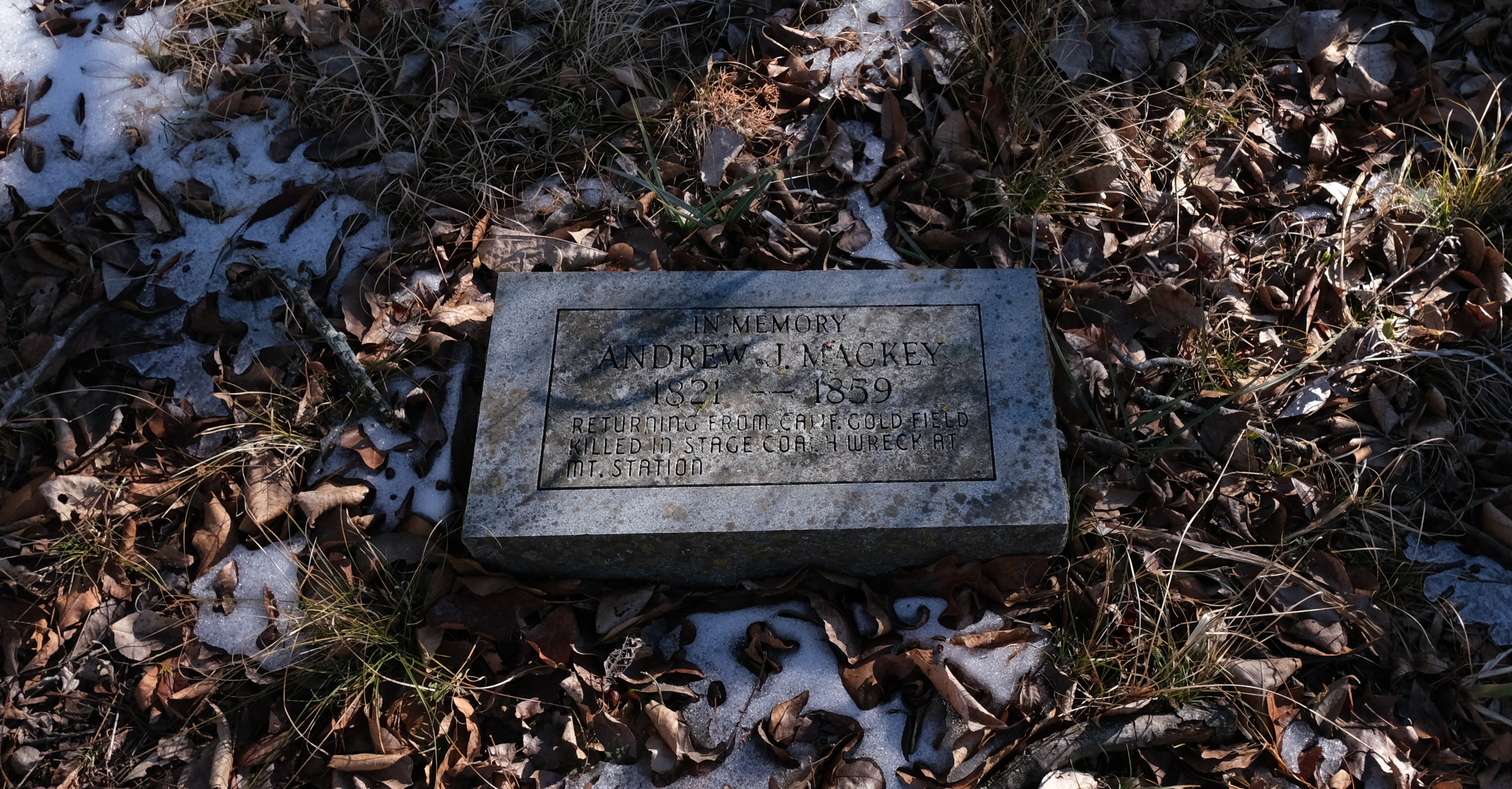
Mountain Station is located in present-day Latimer County, Oklahoma. An interview with Latimer County resident James A. Blalack in 1937 provides another clue. Blalack stated that his grandfather was Andrew Mackey.
He had been to California to the Gold rush in about the year of 1848 and he was on his way home or back to this county and the Indian Territory and was almost home when the stage coach team ran away. This happened at the top of a large mountain called Mountain station. This stage station was located about ten or eleven miles southwest of where Wilburton is now located where all stages that ran on the through road from Fort Smith to the Texas border had to stop for food and water. As they started down this mountain, the team ran away and my grandfather was killed in the smash. He was buried in the Mountain Station burying place. This was during the year 1858. The people who live around in these mountains still use this old burying place now. This place is one of the oldest landmarks in the whole country.
At the time of the interview, Mr. Blalack was a seemingly clearheaded sixty-nine years of age, and his mother, who would have been Andrew Mackey’s daughter, Sallie Mackey Blalack, was living with him, in her early eighties. She would have been ten years old at the time of the accident, probably old enough to remember the event, although the exact year of the accident is mis-reported. Available historical records place Andrew Mackey in Cassville, Missouri, in the 1840s and in Athens, Missouri, in 1850 when his daughter Sarah (Sallie) was born.
The Clock Tells the Story
During a research foray in 2022, Latimer County rancher and historian Earl Shero took me to the spot at Mountain Station where the accident may have occurred. He pointed out the steep descent where the stagecoach would have careened out of control, crashing into the trees on the rocky hillside. There in the Mountain Station cemetery I also saw the grave marker for Andrew Mackey, easy to find because it is so new in the old graveyard, placed recently by one of his Blalack descendants. The marker reads:
In Memory
Andrew J. Mackey
1821-1859
Returning from Calif. Gold Field
Killed in Stage Coach Wreck at
Mt. Station
The year of death on Mackey’s grave marker may be incorrect, but in the end the clock tells the story. The accident occurred on the evening of Friday, July 20, 1860. Late the following day, July 21, news of the accident had reached Van Buren, Arkansas, a town adjacent to Fort Smith, just across the Arkansas River. The only way this could have occurred would have been via a person on horseback or by stagecoach, as the telegraph line had not yet been extended to northwest Texas or Indian Territory. A stagecoach traveling at the average speed of 5.5 miles per hour expected over Indian Territory roads could have traveled the nearly 100 miles from Mountain Station to Fort Smith in about 17 hours, a man on horseback much faster. The average speed of the Pony Express was 10 miles per hour, but that speed was achieved because a fresh horse was acquired every 10 to 15 miles. At that brisk rate an express rider could have reached Fort Smith in about 10 hours, although in reality it would have taken somewhat longer.
Mountain Pass Station in Texas was 487 miles from Fort Smith, requiring nearly five days’ travel in a stagecoach and at least two days by horseback under the best possible circumstances. When the report of the accident was received in Fort Smith, a coach was dispatched immediately to attend to the wounded and by July 23, 1860, thanks to extension of the Missouri and Western telegraph line to Fort Smith, word of the accident had been disseminated all over the eastern United States. By the time the injured passengers arrived in Fort Smith on Sunday, July 22, a wagon carrying passengers from Mountain Pass, Texas would have still been about three days away. The timeline stands on its own in clarifying that it would have been a physical impossibility for the passengers to have arrived from Mountain Pass Station, Texas, to Fort Smith, Arkansas, by July 22, 1860.
Given the evidence, it is reasonable to conclude that Mountain Station in the Choctaw Nation of Indian Territory, not Mountain Pass Station in Texas, was where Mackey met his maker, Muybridge’s life was changed, and the invention of moving pictures was set in motion.
Want to support the Oklahoma Chapter of the Butterfield National Historic Trail Association in its mission to preserve, promote and protect the Indian Territory segment of the trail? Join the National Association and the Oklahoma chapter here: https://www.butterfieldtrail.org/
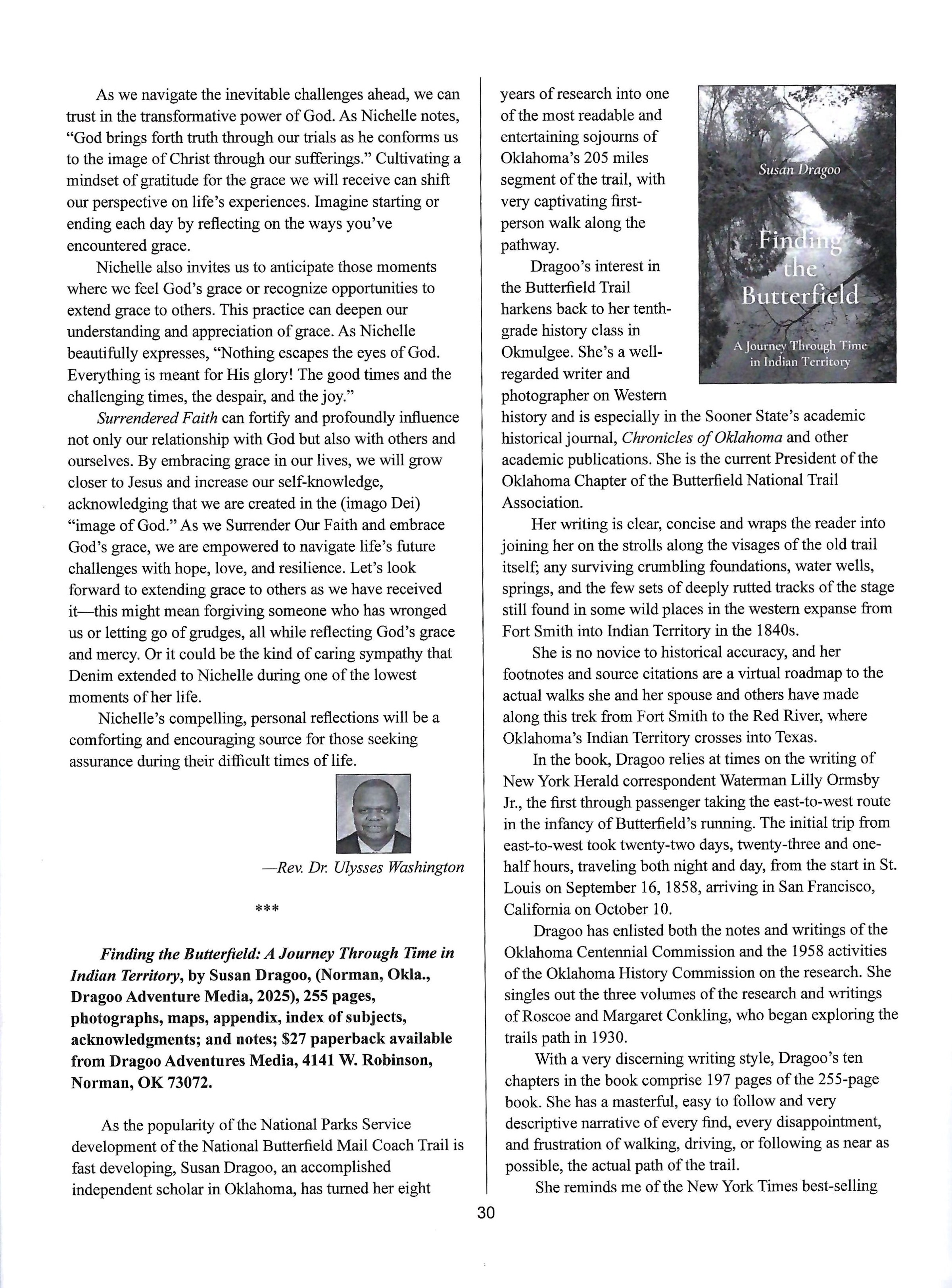
Thanks to Maylon Rice for this review of my book, “Finding the Butterfield: A Journey Through Time in Indian Territory,” in the latest issue of the Fort Smith Historical Society Journal! Read it below and go to https://susandragoo.com/butterfield-oklahoma/ for more on the book!
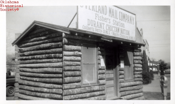
It’s been a mystery for many years . . . who was the “Fisher” of Fisher’s Station, the eleventh (counting east to west) in a chain of twelve official relay stations on the Indian Territory segment of the Butterfield Overland Mail stagecoach road? That mystery may now be solved, thanks to an item in a 1924 edition of a Durant, Oklahoma, newspaper, and other evidence which leads to the conclusion that the likely operator of Fisher’s Station was David Osborn Fisher, a Choctaw citizen who was married to a Chickasaw woman and was also adopted into the Chickasaw tribe.
The Butterfield Overland Mail in Indian Territory
The Butterfield Overland Mail operated from 1858 to 1861, extending from St. Louis, Missouri, and Memphis, Tennessee, to San Francisco, California. Nearly two hundred miles of the 2,800-mile trail ran through the Choctaw and Chickasaw Nations in Indian Territory. Located about four miles west of present-day Durant in Bryan County, Fisher’s was the last station in the Choctaw Nation; the stagecoach road entered the Chickasaw Nation about three hundred yards west of the stage stand.
Hand-drawn map by Muriel Wright from “Historic Places on the Old Stage Line,” Chronicles of Oklahoma, 1933.
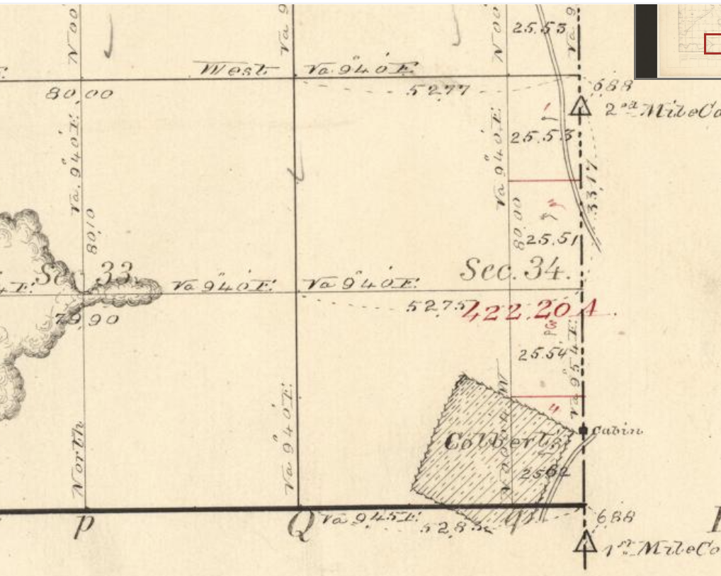
After the demise of the Butterfield line and following the Civil War, the stage stand was known as Carriage Point, possibly because an old carriage broke down nearby during the War and was left to the ravages of time. In 1869, Calvin Colbert bought the stage stand and it became an overnight stop for stagecoach travelers.
1871 map showing Carriage Point (lower right corner, see Cabin east of Colbert’s field).
Near Fisher’s/Carriage Point the road forked, one branch running south on the Butterfield trail toward Colbert’s Ferry and Sherman, Texas; the other going at a more southwesterly angle, entering Texas at Preston Bend, now under the waters of Lake Texoma. An 1872 newspaper advertisement for the Red River ferry at Preston Bend advises taking “all right hand roads” from Carriage Point to get there.
While the name of the station has long been known via publication of Overland Mail itineraries, the identity of the Fisher’s station keeper has remained a mystery since historians began studying the Butterfield trail. In Indian Territory, most station operators were known to be citizens of the Choctaw Nation, or in one case the Chickasaw Nation. The origins of three station keepers have, however, eluded researchers: Waddell’s, Holloway’s, and Fisher’s.
Butterfield Overland Mail itinerary according to W. Goddard Bailey, 1858, published in Conkling. The Seventh Division is the Indian Territory segment.
Muriel Wright’s Theory
Oklahoma historian Muriel Wright invested considerable energy into the question of who ran Fisher’s Station. Correspondence between her and Butterfield scholar Roscoe Conkling in 1935 indicates Wright believed Fisher’s was connected to Fisher Durant, a family member of Dixon Durant, a Choctaw for whom the town of Durant was named. In trying to determine the identity of the station keeper, Wright first considered the Choctaw Fisher family – Silas Fisher, Osborn Fisher, et al. But she concluded that since Silas Fisher had remained in the lower Red River country after the removal and Osborn Fisher ranched and operated a store near Daisy in northeast Atoka County and then settled in Tishomingo, this would be unlikely.
Instead, she noted that the earliest site of the city of Durant was actually made by Fisher Durant, and was known in early days as “Fisher’s Place.” She postulated that the Butterfield road had actually come through Durant, and that Fisher’s Place had been Fisher’s Station. Conkling doubted this conclusion, first pointing out that the Fisher Durant location did not fit into the Butterfield table of distances and the route would have required “a rather rank bend to the east and then southwest again,” a deviation that the road builders would have avoided. “I have investigated the route from Nail’s to Carriage Point and from there to Colbert’s in the field with some of the oldest men in the region and if there was any other road between these points followed by the Overland Mail, these men had never heard of it,” wrote Conkling.
Roscoe Conkling’s Theory
But, Conkling conceded, this did not mean that the station could not have been named for Fisher Durant. He could have been employed by the Overland Mail Company as a station keeper and the station named for him even if his home was near the present location of Durant, but it would seem that some reference to this would have been handed down to his descendants. More likely, wrote Conkling, Fisher was among the more than two hundred Butterfield employees from New York brought west to work on the Overland Mail and placed in charge of stations during the first year of operations. “I was told by the then oldest living employee of the old Wells-Fargo Company, who died some years ago in Utica, that Mr. Butterfield transported more than two hundred of his old employees in New York to the western field to work on the Overland. Many of these were placed in charge of stations during the first year of operations,” Conkling wrote. Few of these remained long, but long enough to have their names identified with the stations along the route, and “for that reason no record can be found to prove their identity,” he added. Conkling included Holloway and Waddell among these.
Wright stuck to her guns, however, asserting it would be too much of a coincidence if Fisher Durant, “the most prominent Choctaw citizen in his locality” had nothing to do with Fisher’s Station, in spite of the fact that his known dwelling was in Durant, four miles east of the stage stand. “He could have owned an extra ranch cabin or erected one specially for a stand on the stage line road west of his home place,” she explained. Wright concluded, “And now I feel almost certain, it must have been that of Fisher Durant.”
It appears that, in the end, Wright and Conkling agreed to disagree. Roscoe and Margaret Conkling wrote in their 1947 tome on the Butterfield, “Because the station ceased to be known as Fisher’s after the Company abandoned the route in 1861, and the old name of Carriage Point restored, it has been suggested that Fisher may have been in the Company employ and temporarily installed there.” Wright later wrote in an appendix to her 1957 article, “The Butterfield Overland Mail One Hundred Years Ago,” that Fisher was a member of a well-known Choctaw family. And in the 1958 Centennial Committee Report, she simply quotes Conkling’s conclusion.
A Different Conclusion
Further research suggests a different conclusion. It seems Wright probably dismissed too quickly the Silas Fisher/Osborn Fisher family as a possibility. In 1924, the Durant Daily Democrat reported a talk given by Jessie M. Hatchett, grand-daughter of Calvin Colbert, who operated the Carriage Point stage stand beginning around 1869. Hatchett stated, “The place was first settled by the Rider family, afterwards owned by the Fishers of Tishomingo, from whom it was purchased by my mother’s father.”
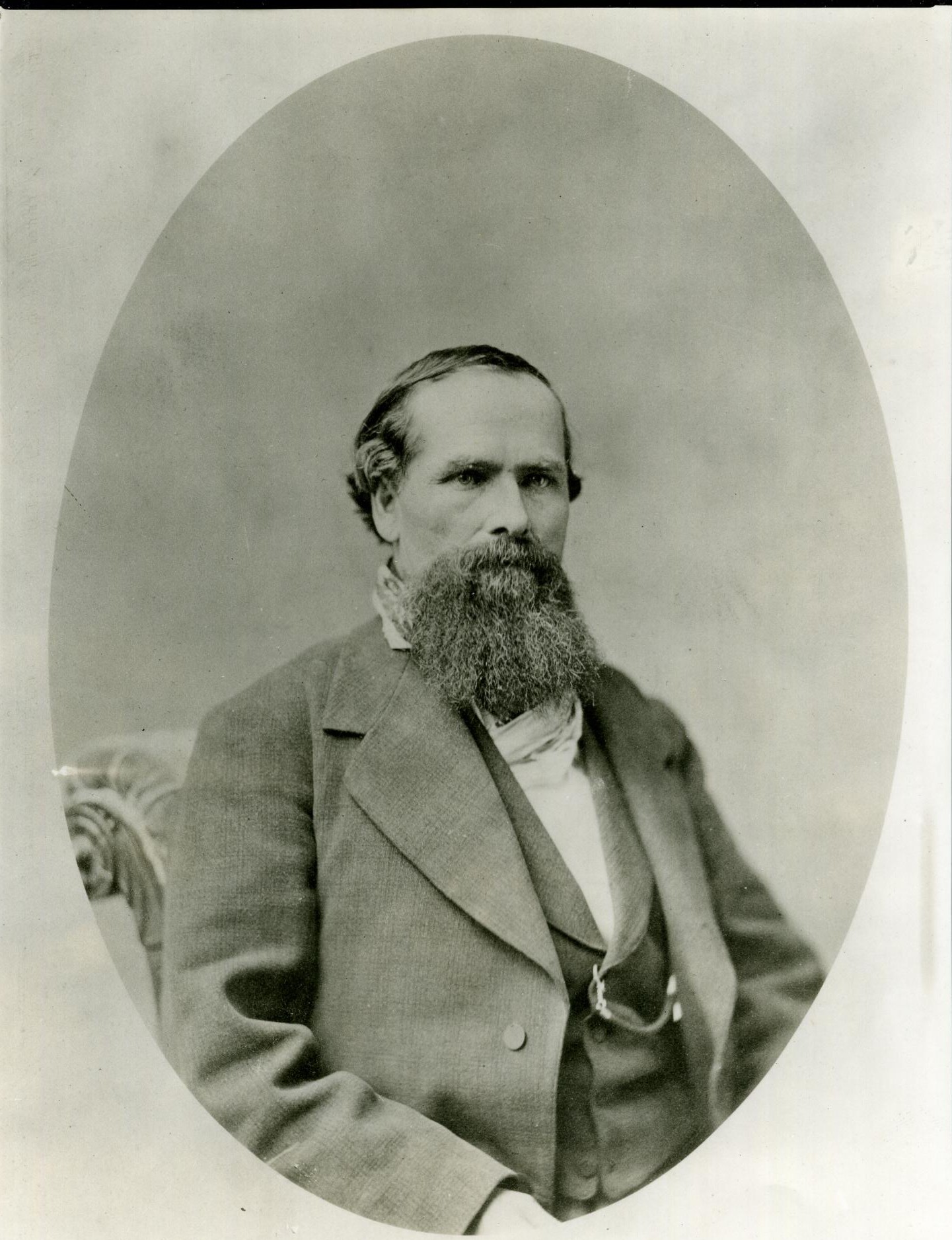
David Osborn Fisher. Source: Oklahoma Historical Society
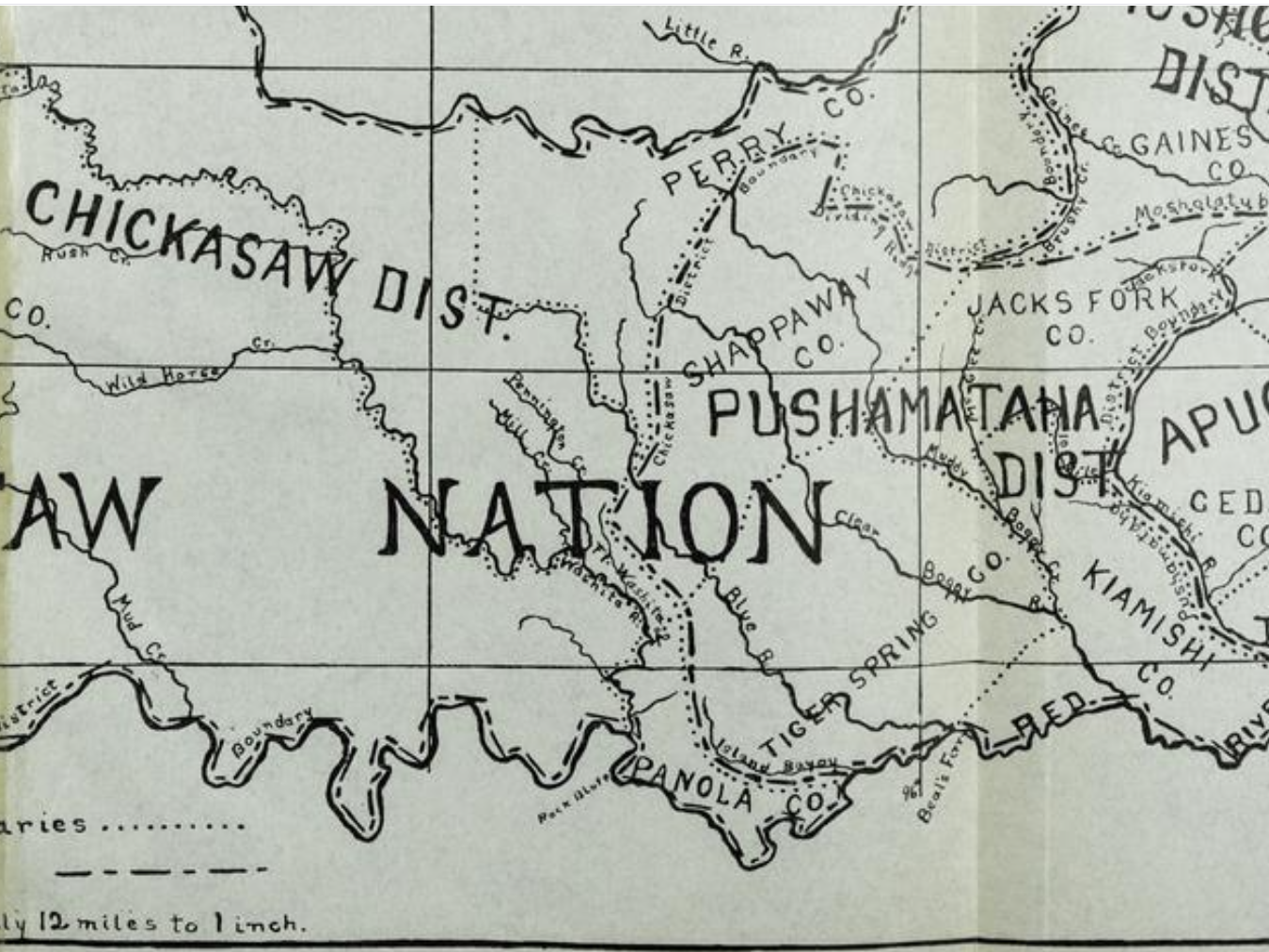
Given that Silas Fisher died in 1849, Osborn Fisher is the more likely candidate. David Osborn Fisher was born in 1825 in Mississippi and moved to Indian Territory with the Choctaws in 1832. In 1837 he relocated to Fort Washita, later establishing a large farm on Red River in Panola County in the Chickasaw Nation. The 1860 federal census (slave schedule) finds him in Blue County (formerly Tiger Spring County) in the Choctaw Nation, where Fisher’s Station was located. There, Fisher enslaved 24 people.
Note (see map below) that Panola County in the Chickasaw Nation bordered on Blue (Tiger Spring) County in the Choctaw Nation, and that Fisher’s Station in the Choctaw Nation was located only three hundred yards east of the Panola County line. Fisher was a member of both the Choctaw and Chickasaw Nations, having been adopted by the Chickasaws by an act of the legislature during the Civil War. Thus, he may have held land in both domains.
1850 map of Choctaw and Chickasaw counties. Panola County’s (bottom center) borders remained the same after separation of the Chickasaws from the Choctaws in 1855. Tiger Spring County was later renamed Blue County. Source: Muriel H. Wright, Chronicles of Oklahoma. “Organization of Counties in the Choctaw and Chickasaw Nations” (Autumn 1930).
Before moving to Tishomingo in 1879 where he operated a “mercantile business on a large scale,” Fisher served in the Civil War in the Choctaw and Chickasaw Regiment under Tandy Walker; ran a store, stage stand and post office in Perryville; was active in politics; and operated a cattle business. Fisher was also a prominent banker in Denison, Texas, and died in Tishomingo in 1898.
1860 Slave Schedule for Blue County, Choctaw Nation. D.O. Fisher listing in right hand column.
Source: The Daily Ardmoreite, October 24, 1898, page 1
Supporting the reliability of Hatchett’s statement that the Fishers acquired the property from the Rider family, the gravestone of Thomas Rider remains on the place. Born in 1814, the date of his death is 1863, so the Rider family may have maintained some connection to the area after selling the place to Fisher. Based on 1860 census records (slave schedule), Thomas Lewis Rider was living in Saline County, Cherokee Nation in 1860, enslaving 11 people. He enlisted as a private at the age of 47 in the Cherokee Mounted Volunteers in 1861. According to civilwaralbum.com, Rider served as a staff mail carrier for Gen. Stand Watie and Gen. Douglas H. Cooper, Confederate States of America (CSA), from 1861 until his death on August 17, 1863. In this capacity, Rider carried mail from CSA headquarters to troops operating in the field, or camped for a time resting and foraging. His son, age 16, replaced him in the field after Rider died and claimed that the “work was dangerous.” For more information see https://www.civilwaralbum.com/indian/rider1.htm
Roscoe and Margaret Conkling photo of structure at Carriage Point, 1930.
When Roscoe and Margaret Conkling visited Fisher’s Station in 1930, they saw relics of the stage road stretching north and southwest, with several sets of ruts. A building constructed of very old logs remained, probably the last portion of the station then standing. The structure had been improved and added to, but the old section was readily discernible. At the station site they also saw the caved-in well, very old timbers, and foundation stones.
A replica of Fisher’s Station was built for the 1957 Oklahoma Semi-Centennial and displayed at the semi-centennial exposition in Oklahoma City, then moved to Durant for the 1958 celebration of the Butterfield Centennial.
Replica of Fisher’s Station built for 1957-1958 centennial of the Butterfield Overland Mail and Oklahoma semi-centennial. Source: Oklahoma Historical Society.
Today, the old well and Rider gravestone are the most discernible remnants of Fisher’s Station, operated not by Fisher Durant nor a Butterfield employee from the east but by a man belonging to both the Choctaw and Chickasaw Nations, Osborn Fisher.
Thomas Rider grave at Fisher’s Station. Photo by the author.
For more information on the Butterfield in Indian Territory, see Finding the Butterfield: A Journey Through Time in Indian Territory, available on Amazon at https://a.co/d/aiHX4y4.
Roscoe P. and Margaret B. Conkling, The Butterfield Overland Mail, 1857–1869: Its Organization and Operation over the Southern Route to 1861; Subsequently over the Central Route to 1866; and Under Wells, Fargo and Company in 1869. 3 vols. Glendale, Calif.: Arthur H. Clark, 1947. Vol. 1 of 3, 154.
J.Y. Bryce. “Perryville at One Time Regular Military Post,” Chronicles of Oklahoma 4 no. 2 (Summer 1926).
J.Y. Bryce, “Temporary Markers of Historic Points,” Chronicles of Oklahoma 8, no. 3 (September 1930)
“Carriage Point,” Works Progress Administration Historic Sites and Federal Writers’ Project Collection. Western History Collections. Box 17 Stage Stops and Newspapers, Folder 4.
M. Ruth Hatchett. “Necrology: Isabelle Rebecca Colbert Yarborough.” Chronicles of Oklahoma 37 no. 3 (Autumn 1959).
“Indian Territory is Rich in History,” Durant Daily Democrat, January 28, 1924, 2.
W.B. Morrison. “Colbert Ferry on the Red River, Chickasaw Nation.” Chronicles of Oklahoma 16 no. 3 (September 1938).
“Preston Ferry,” The Vindicator (Atoka, C.N.), July 11, 1872.
Roscoe Conkling Papers. Seaver Center for Western History Research, Los Angeles, Calif.
Muriel Wright to and from R.P. Conkling, October 28, 1935, November 1, 1935, November 7, 1935. Muriel Wright Collection. Box 7, Folder 34.
Muriel H. Wright; Vernon H. Brown, John D. Frizzell, Mildred Frizzell, James D. Morrison, Lucyl A. Shirk, and George H. Shirk. “Committee Report Butterfield Overland Mail.” Chronicles of Oklahoma 36, no. 4 (Winter 1958).
Muriel H. Wright. “Historic Places on the Old Stage Line from Fort Smith to Red River,” Chronicles of Oklahoma 11, no. 2 (June 1933).
Muriel H. Wright. “The Butterfield Overland Mail One Hundred Years Ago.” Chronicles of Oklahoma 35, no. 1 (Spring 1957).
“The End of a Busy Life,” The Daily Ardmoreite, October 24, 1898, 1.
Here’s the first edition of the quarterly newsletter for the Oklahoma Chapter of the Butterfield National Historic Trail Association. Contents include news about the Edwards Store, a trail guide for a segment of the Butterfield Trail at Lake Atoka, and a photographic retrospective on Nail’s Crossing. Join the National and Oklahoma BNHTA for early access to the next newsletter!