Oklahomans of the 21st Century, if they think about it at all, might like to imagine a location within the state’s borders as its birthplace: perhaps the Three Forks region near Muskogee, where fur traders headquartered in the early 1800s, or Purcell, the southern border of the April 1889 land run. Or there’s Guthrie, the state’s first capital. But just east of the Oklahoma border, Fort Smith, Arkansas deserves credit for its significant role as the primary portal for the 19th century exploration and settlement of its western neighbor, and it is the starting point for our contemporary journey through time and across Oklahoma along an ancient road.
When rivers were the highways of America, Fort Smith’s position at the head of navigation of the Arkansas River made it an essential gateway to the frontier for the U.S. military, traders, and other explorers. Through it passed many of the eastern Indian tribes as they migrated or were moved west to Indian Territory. It was a supply depot for forts established farther west, and late in the 1800s it was the source of law and order in the region.
At the time of first European contact in the 1500s, Oklahoma’s native inhabitants included the Wichitas, Caddos, Plains Apaches, and Quapaws. People of the Caddoan Mississippian Culture left evidence of their occupation of eastern Oklahoma through numerous mound sites, Spiro Mounds being the only one now open for public view. Over the next three centuries, the area was explored by the Spanish but more intensively used by the French, who ventured there for trapping and fur trading.
In 1803 the piece of geography we now call Oklahoma (except for the Panhandle) became part of the United States with the Louisiana Purchase, in which 828,000 square miles of territory were acquired from France, doubling the land mass of the U.S. The lands comprising the Oklahoma Panhandle were acquired by the United States after the Mexican War of 1846-1848.
The French left little, if any, physical evidence of their presence, but from them we have something more enduring: place names for natural features and settlements. Among them are rivers and creeks called Verdigris, Poteau and Sallisaw, a mountain range known as Sans Bois, and a town named Salina (said to be the oldest permanent settlement in Oklahoma, established by fur trader Jean Pierre Chouteau in 1796).
Just across the water from the eastern border of present-day Oklahoma, a bluff overlooking the confluence of the Poteau and the Arkansas Rivers was also given its name by French traders. Belle Point was selected in 1817 as the site of an Army post, at the time the westernmost of the United States, established to quell the ongoing conflict between the Osage and Cherokee tribes. Since European arrival in America, Osages, Pawnees, Kiowas, and Comanches had migrated into Oklahoma, displacing many of the earlier peoples. The region on the lower Arkansas River was claimed by the Osages at the time, but federal officials urged Cherokees from Georgia and Tennessee to move to the area. When nearly 2,000 Cherokees emigrated west and settled in what is now western Arkansas, turmoil ensued.
Major William Bradford was commanded to establish the new fort on the Arkansas River. On Christmas Day 1817, he arrived with his troops at Belle Point after a three-month journey from Belle Fontaine, an army post on the Missouri River near St. Louis. His transport was a keelboat, a slow, unpowered river boat controlled by oars or poles. At Belle Point his men pitched tents for shelter and began cutting timber for construction of the post, named for General Thomas A. Smith, who selected Bradford for the command.

Early Observations by an Englishman
Early observations of Fort Smith and the future Oklahoma came from travelers such as naturalist Thomas Nuttall, an Englishman who came to the U.S. to study its flora. In October 1818 he set out from Philadelphia intending to reach the Rockies by way of the Arkansas River Valley. Seven months later he arrived at Fort Smith, then the edge of the frontier, in a pirogue, or dugout canoe, after a challenging journey on the Ohio, Mississippi and Arkansas Rivers. In 1821 he published A Journal of Travels into the Arkansas Territory in the Year 1819, leaving a detailed picture of what he saw during his 1819 visit, including this observation of his arrival at Belle Point:
April 24, 1819: This morning we passed the hills of Lee’s creek, which for a short distance border the Arkansas; and about noon arrived at the garrison, which comes into view at the distance of about four miles, agreeably terminating a stretch of the river. Rising, as it were, out of the alluvial forest, is seen from hence, at the distance of 35 miles, a conic mountain nearly as blue as the sky, and known by the French hunters under the name of Point de Sucre, or the sugar loaf.
****
April 24, 2014: Thus, Sugar Loaf Mountain was Thomas Nuttall’s first recorded sight of what would become Oklahoma. On a rainy April 24th 195 years later, I stood near the water’s edge on Belle Point’s black stone landing. In an attempt to replicate Nuttall’s sighting, I looked in the distance for the 2,600-foot peak, actually about 25 (rather than 35) miles south, and 10 miles east of present-day Poteau.

I had been here a few months before, in the winter, when the river was lower and afforded better access to the rock slabs along the shore, their layers of slate thin and flaky. Nuttall had described them as “a dark-coloured slaty micaceous sandstone, the lamina of which, nearly horizontal, and occasionally traversed by calcareous illinitions, are about four to six inches in thickness, and denudated for some hundreds of yards by the washing of the current, which, in an elevated stage, roars and foams with great velocity.”
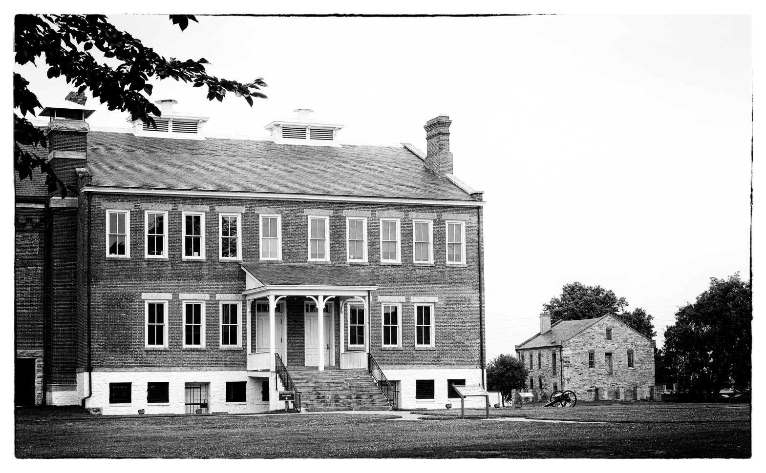
The Fort Smith National Historic Site, administered by the National Park Service (NPS) graces this elevation today and the river here is wide and deep, not the stream that “roars and foams with great velocity.” The locks and dams of the McClellan-Kerr Arkansas River Navigation System, opened in 1971, now control these waters, maintaining a minimum depth for cargo vessel navigation.
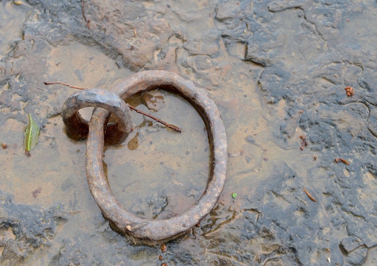
During my winter visit a few months before I had noticed hand-forged eye bolts driven into the stone along the river. In the Visitor Center of the Historic Site, I asked the park rangers about the eye bolts. They said they don’t tell people about them because they don’t want them to disappear. As best they know, they are from the early fort and served as attachments for moorings. “The 1817 fort?” I asked.
“Could be,” they replied vaguely.
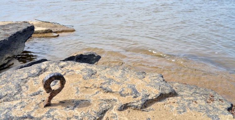
(On a more recent visit I queried a NPS volunteer on the same subject. Are the rings a product of the first or second fort? “The second,” he said confidently. Given that I had just overheard him telling other visitors that Fort Towson, located near the mouth of the Kiamichi in southern Oklahoma, is in Texas, I didn’t put much stock in his answer.)
On that April morning in 2014, I approached the fort from the west by way of the Garrison Street Bridge, which crosses the river at a great height and offers a spectacular view of Belle Point and the confluence of the two rivers.
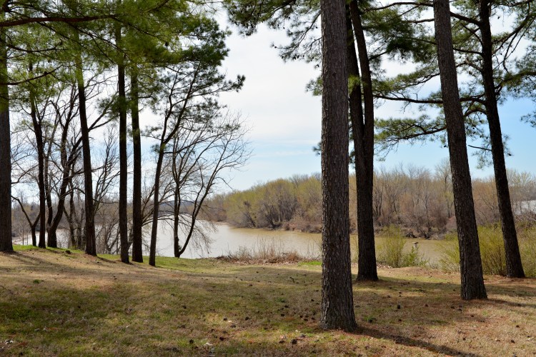
Just after noon, around the same time Nuttall arrived, I stood looking out upon the waters. There was a light breeze and the temperature was mild, with heavy clouds and intermittent rain. The waters of the Poteau and the Arkansas mingled at my feet, lapping against the projection of black stone. I stood and listened. The train whistle in the distance—a constant in my lifetime — had never been heard here when Thomas Nuttall arrived. I heard the coo-ooh, coo, coo of the mourning dove, the honking of airborne geese, and the dull roar of auto traffic on the highway. A goose waddled nearby and birds sang in the forest canopy. Elm and live oak trees were dressed in a fresh spring green, their color intensified by moisture and diffused light. Water stood in pools on the rocks. I saw a power line tower across the river but no mountains visible in the distance; the horizon was obscured by low clouds.

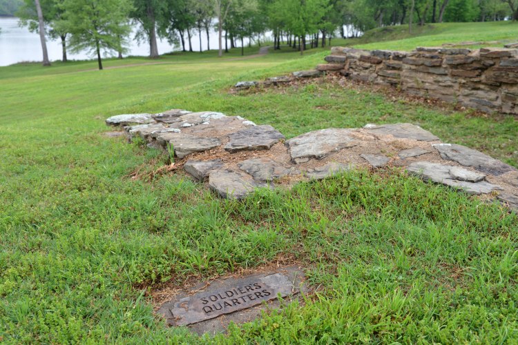
Atop the bluff, stone foundations from the 1817 fort have been excavated; I walked up to the higher elevation and stood at the soldiers’ quarters. The view is everything Nuttall describes: “. . . on a rising ground of about 50 feet elevation, and surrounded by alluvial and uplands of unusual fertility. The view is more commanding and picturesque, than any other spot of equal elevation on the banks of the Arkansa

But I was never able to re-live Nuttall’s first sight of Oklahoma from Belle Point; even with repeated attempts Sugar Loaf was not visible from either the river elevation or the bluff, but on a clear day I easily spotted it while driving along Interstate 40. Did Nuttall actually see Sugar Loaf from river level, or did his recording of the event get mixed up with his later sightings from a better vantage point? We may never know. He remained at the fort for several weeks, exploring and collecting plant specimens. Traveling southeast to Cedar Prairie, he remarks again on the view of Sugar Loaf as well as “the Cavaniol,” which he describes as appearing the higher of the two. Today, Cavanal Hill is billed as “the world’s highest hill,” by the Poteau Chamber of Commerce at 1,999 feet elevation, about 600 feet lower than Sugar Loaf. (The actual elevation of the summit of Cavanal is 2,385 feet above sea level, making Nuttall a little more accurate than the Poteau Chamber of Commerce in this case.)
Before continuing west toward the Rockies, Nuttall traveled south to the Red River with Major Bradford and a company of soldiers. Departing on May 16, they crossed the Winding Stair Mountains to the junction of the Kiamichi and the Red Rivers. Deer, bear, and bison were abundant, and ticks were troublesome. The troop’s objective was to remove white squatters from land claimed for the Indians. When the troop returned to Fort Smith, Nuttall was left behind, having returned late to camp from botanizing, and missing his party’s departure. He would not reach Fort Smith again until June 21, traveling with a party of settlers going there to recover stolen horses. Soon, Nuttall obtained passage with trader Joseph Bogy to Three Forks — the confluence of the Arkansas, Verdigris and Grand Rivers near present-day Muskogee — and departed on July 6 on the 130-mile river journey. Read about the rest of Nuttall’s adventure at https://susandragoo.com/wp-content/uploads/2013/07/nuttall.pdf
****
Ups and Downs: 1817 to 1824
In the years following Fort Smith’s establishment, other frontier tensions added to the challenge of Major Bradford’s job of dealing with the Cherokee-Osage conflict. Settlers from the Territory of Arkansas squatted on Cherokee lands and encroached upon Lovely’s Purchase, intended as a buffer zone, leading to complaints from both Cherokee and Osage leaders. Groups of Arkansas settlers occupied lands claimed by the Osages west of the Kiamichi (in present southeastern Oklahoma) on the Red River, and Bradford was instructed to force them east of the Kiamichi. It was this situation that prompted the Red River journey on which Thomas Nuttall accompanied Bradford during May of 1819.
The government decided to increase military strength at Fort Smith in 1822, although later that year the tensions between the Cherokee and Osage were quelled after a peace council at the fort. In February, the 7th Infantry reached Fort Smith and Major Bradford turned the station over to Colonel Mathew Arbuckle. The next month, in March of 1822, the first steamboat, the Robert Thompson, reached Fort Smith, coming from Pittsburgh towing a keelboat full of supplies. This was a significant mark of progress, for steam navigation of the Arkansas to Belle Point speeded communication with and delivery of supplies from the East.
By this time, according to Bearss and Gibson in Fort Smith: Little Gibraltar on the Arkansas, Fort Smith had “evolved from a primitive military station to a fort of the first order, and the tidy log and rock buildings, expanded palisade walls, and enlarged garrison elicited respect for U.S. authority and an acknowledgment of its determination to achieve border peace.” But within only two years, Fort Smith’s role as a frontier protection point had diminished. Colonel Arbuckle had recommended to the War Department as early as 1822 that the Fort Smith garrison relocate farther west to a more strategic spot. Cherokee – Osage problems had lessened and a frontier town was growing at Belle Point, creating opportunities for trouble for the troops (primarily whisky and women).
Other forces were also at work. Leaders in Arkansas Territory wanted to expand their domain as far to the west as possible in anticipation of statehood. Their delegate to the U.S. Congress proposed that Arkansas Territory be allowed to annex land west of Fort Smith on a line from the mouth of the Grand River south to Red River. Territorial leaders saw the garrison at Fort Smith as less a permanent installation at Belle Point and more a mobile force to serve the western border defense needs, which they anticipated would move farther west, according to Bearss and Gibson.
Arbuckle received orders to abandon the Belle Point location in April of 1824, and the garrison moved overland along a “well-marked trace skirting the north bank of the Arkansas” to the new installation on the east bank of the Grand River, named “Fort Gibson” after Commissary General George Gibson.
****
Road Building and The Removal: 1824 to 1838
Fort Smith began to deteriorate quickly after the departure of the 7th Infantry; log walls began to rot, and windows and doors were carried off by settlers from the nearby town for use in their own dwellings.
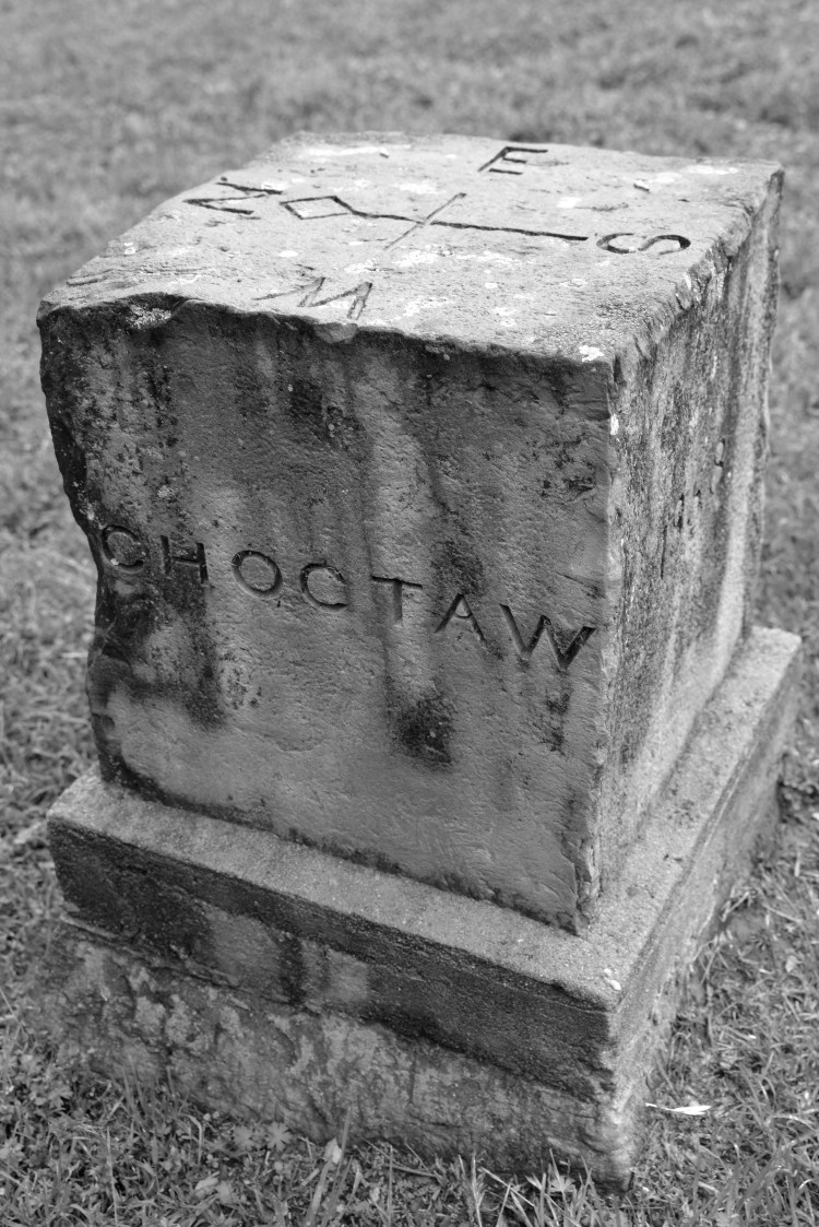
Still, official purposes were found for the fort, including service as headquarters for the Choctaw Boundary Commission in 1825 and 1826. While the expectation that Arkansas’ western boundary would move west to the Grand River had been one of the principal reasons for relocating the Fort Smith garrison to its new post, instead the 1825 Choctaw Boundary Treaty set the Choctaws’ eastern boundary and Arkansas’ western boundary on a line beginning on the Arkansas River 100 paces east of Fort Smith and running due south to Red River. The federal government pledged to remove settlers west of that line, and Choctaw leaders agreed to relocate their people west of the line. (Some were then living east of the boundary on land south and west of Fort Smith granted the Choctaws in the 1820 Treaty of Doak’s Stand.) Arkansas officials protested but plans went forward to enforce the treaty. The Boundary Commission established its headquarters at Fort Smith in November, 1825 and completed its work of establishing the Arkansas-Choctaw Nation boundary in January, 1826. A stone marker on the grounds of the Fort Smith National Historic Site indicates the boundary line; the original marker is on display in the Visitor Center.
Also in 1825, Fort Smith was designated headquarters for the Western Choctaw Agency. Choctaw Agent William McClellan later moved the agency west into present-day Oklahoma to put some distance between his constituents and the Belle Point townspeople, for whom selling whisky to the Indians was a lucrative activity. This location would ultimately become the village of Skullyville, near the modern town of Spiro, Oklahoma.
And, survey and roadbuilding crews used Fort Smith as headquarters during the 1820s. Between 1825 and 1827 Congress authorized construction of a system of military roads on the Arkansas frontier, all focusing on Fort Smith. Two of these extended west from Fort Smith into what would become Oklahoma: one to Fort Gibson and another to Fort Towson. This “federal highway system” was intended to “improve U.S. defenses on the Southwestern frontier, facilitate communications in that region, encourage settlement and development in western Arkansas, and assist the federal government in relocating Eastern tribes in the Indian country west of Fort Smith,” according to Bearss and Gibson.
Illustrating the significance of the fort’s strategic location on Belle Point, all primary military roads on the Arkansas frontier radiated from Fort Smith, and points of reference for the Southwest were usually stated in such terms as “west of Fort Smith,” “south of Fort Smith,” “east of Fort Smith.”
In the spring of 1827 road construction began and, by September, the road from Fort Smith to Fort Gibson was complete. Later that year, the road was surveyed southwest from Fort Smith to Fort Towson, and troops from Towson worked from the Red River northeast toward Belle Point through the Kiamichi Mountains.

The Army temporarily returned to the fort in 1836 to provide supplies to relocating tribes during the Trail of Tears. From 1831 to 1842 the Cherokee, Chickasaw, Choctaw, Muscogee (Creek), and Seminole nations were relocated to Indian Territory over several east-to-west routes collectively known as the Trail of Tears. Over 10,000 died along the way. An overlook commemorating this tragic event is located at Belle Point.

Ashes to Gold: 1838 to 1861
Dissatisfied with the lack of a standing military force after the garrison moved to Fort Gibson and missing the economic benefits that went along with it, Fort Smith citizens and politicians campaigned to have the post restored to Belle Point, basing their demands on unfounded claims that they feared Indian attacks. The campaign bore fruit, and construction began in 1838 on a new fort, which was eventually completed in 1846.
Fort Smith was a busy place during these years, serving as a base for arming and equipping military units for service in the Mexican War and as headquarters for exploration across the Southwest. It supplied Fort Gibson, Fort Wayne, Fort Towson, Camp Washita, Camp Holmes, and Camp Mason, all within the boundaries of present-day Oklahoma, and served as communications center for the army in the Southwest, headquarters for military officials, and administrative office for Indian affairs west of Arkansas. A new town, also named Fort Smith, grew up on the eastern edge of the military installation and was incorporated in 1842.

Remains of the second fort are still visible at the National Historic Site, including the massive stone Commissary building, the oldest building in the City of Fort Smith, and the Barracks building which was later used as the courthouse and jail during the years of “Hanging Judge” Isaac C. Parker’s court. The foundations of the second fort walls have also been excavated and surround the campus.

The 1848 discovery of gold in California gave Fort Smith another opportunity to seek distinction. A local newspaper editor, John F. Wheeler, saw potential in Fort Smith serving as a launching point for the overland journey to the California gold fields. He led an effort to petition the Arkansas legislature and, ultimately, Congress to survey a road up the Arkansas and Canadian River valleys to Santa Fe. Wheeler contended this would be “the best and shortest route,” with terrain over which wagons would roll relatively free of mountains and which would provide “the best of range, the grass springing up from one month to six weeks earlier” than on the more northerly Santa Fe Trail.
In addition to laying the request before Congress, a U.S. Senator from Arkansas wrote Secretary of War William L. Marcy asking for a detachment of mounted troops to escort the gold seekers. Marcy was interested in establishing new avenues for emigration to lands recently acquired from Mexico and authorized the military escort from Fort Smith to Santa Fe. Thus, orders came from Washington to Colonel Arbuckle in early 1849 to provide the escort for California-bound emigrants gathering at Fort Smith. By March of 1849, every steamboat docking at Fort Smith was packed with Forty-Niners and their camps surrounded the town.
The troops would be expected to protect the emigrants against Indian attack, to smooth the roads on steep grades, and to mark fords along the route. The road would generally follow the south bank of the Canadian River and the watershed between the Canadian and the Washita, thus avoiding bottoms and numerous creek crossings. A detail led by Lieutenant Frederick T. Dent of the 5th Infantry was sent to reconnoiter the best route, and crossed the Poteau on March 27 to open the California Road.
Captain Randolph B. Marcy arrived at the end of March to command the military escort. He struck out along the road on April 4 and, during that month, 400 wagons moved through Fort Smith, with caravans of gold-seekers departing from Fort Smith through the spring and summer.
Marcy reached Santa Fe on June 30 and wrote that emigrant caravans using the Santa Fe Trail were about two weeks behind his own company, reinforcing the pronouncements of folks back in Fort Smith about the advantages of the southern route. The Gold Rush would last about 10 years, and the spectacle at Fort Smith was repeated annually until 1861 and the outbreak of the Civil War. During the 1850s, thousands of emigrants passed through Fort Smith, bound for California.
****
As we trace the California Road “West of Fort Smith” in the 21st Century, we can experience the history, topography and culture of Oklahoma in a unique way. From its genesis in Fort Smith to its exit near the Antelope Hills over 400 miles away, the trail crosses layers of time and space to bring us closer to pre-Civil War Indian Territory and its people and places. Wagons ho!
Coming Soon: Moneytown
Related posts and publications:
The Great Golden Way, Oklahoma Today, September/October 2016
https://susandragoo.com/wp-content/uploads/2013/07/goldenwayso161.pdf
https://susandragoo.com/2016/09/08/the-natural-mounds-of-caddo-county/
https://susandragoo.com/2016/09/01/found-on-the-great-golden-way/
https://susandragoo.com/2016/01/22/wagons-west/
Sources:
Bearss, Edwin C. and Gibson, Arrell M., Fort Smith: Little Gibralter on the Arkansas. Norman: University of Oklahoma Press, 1979.
Nuttall, Thomas (Author), and Lottinville, Savoie (Editor), A Journal of Travels into the Arkansas Territory During the Year 1819, Norman: University of Oklahoma Press, 2012.

Very interesting Susan!
Thanks, Carolyn!
Thanks, Susan. Nice read!!
Thanks!